Space-Time Pattern Mining: Creating and Analyzing 3D Space-Time Cubes

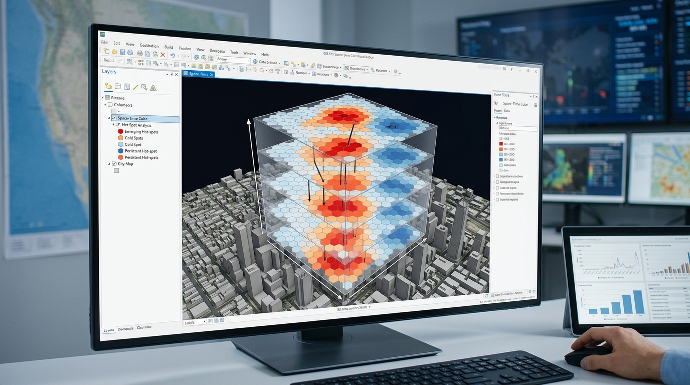
Space Time Pattern Mining 3D Space Time Cubes

Space-Time Pattern Mining: Creating and Analyzing 3D Space-Time Cubes 1. Introduction: Moving beyond static maps When implementing space time pattern mining 3D space time cubes, traditional maps often conceal how geographic patterns develop over time. Traditional GIS maps show where events occur, but a static map can conceal how geographic patterns develop over time. A … Read more
InSAR Surface Deformation Mapping: Tracking Ground Subsidence with Sentinel-1

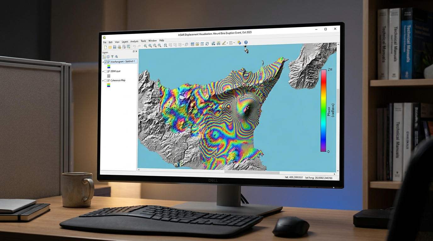
InSAR Surface Deformation Mapping Sentinel 1 Subsidence

InSAR Surface Deformation Mapping: Tracking Ground Subsidence with Sentinel-1 1. Introduction: How InSAR detects ground subsidence When performing InSAR surface deformation mapping Sentinel 1 subsidence, detecting millimeters of ground displacement from satellite radar requires careful processing. Interferometric Synthetic Aperture Radar (InSAR) is a remote sensing technique that measures changes in the distance between a radar … Read more

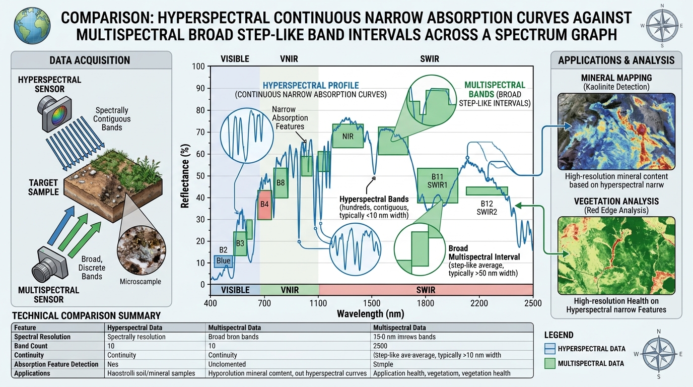
Hyperspectral vs Multispectral Remote Sensing: Spectral Resolution Explained

Hyperspectral vs Multispectral Remote Sensing Spectral Resolution comparison graph of spectral signatures

Hyperspectral vs Multispectral Remote Sensing: Spectral Resolution Explained 1. Introduction: Why spectral resolution matters Remote sensing allows researchers to investigate Earth’s surface by measuring electromagnetic energy reflected, emitted, or scattered by objects. Different materials interact with electromagnetic radiation differently, producing patterns that can help distinguish vegetation, soil, minerals, water, and built surfaces. However, the usefulness … Read more

Geospatial Cross-Validation in Machine Learning: Preventing Spatial Autocorrelation Leakage

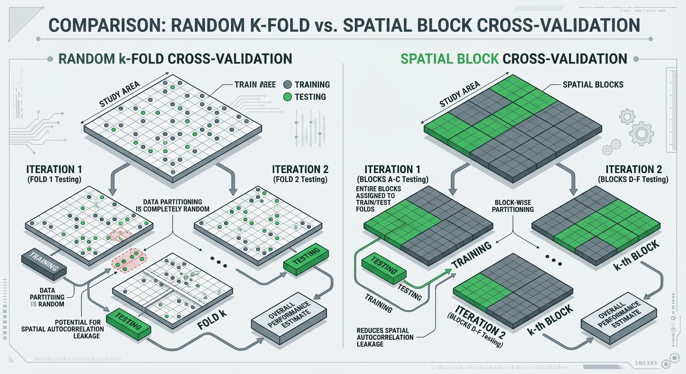
Geospatial Cross Validation Machine Learning GIS block vs random cross validation comparison

Geospatial Cross-Validation in Machine Learning: Preventing Spatial Autocorrelation Leakage 1. Introduction Using Geospatial Cross Validation Machine Learning GIS techniques is essential when modeling spatial phenomena like land surface temperature or soil properties. Machine learning models are increasingly used to predict spatial phenomena, including land surface temperature, soil properties, flood susceptibility, vegetation condition, species distributions, housing … Read more

Querying OpenStreetMap Data at Scale with Python and DuckDB

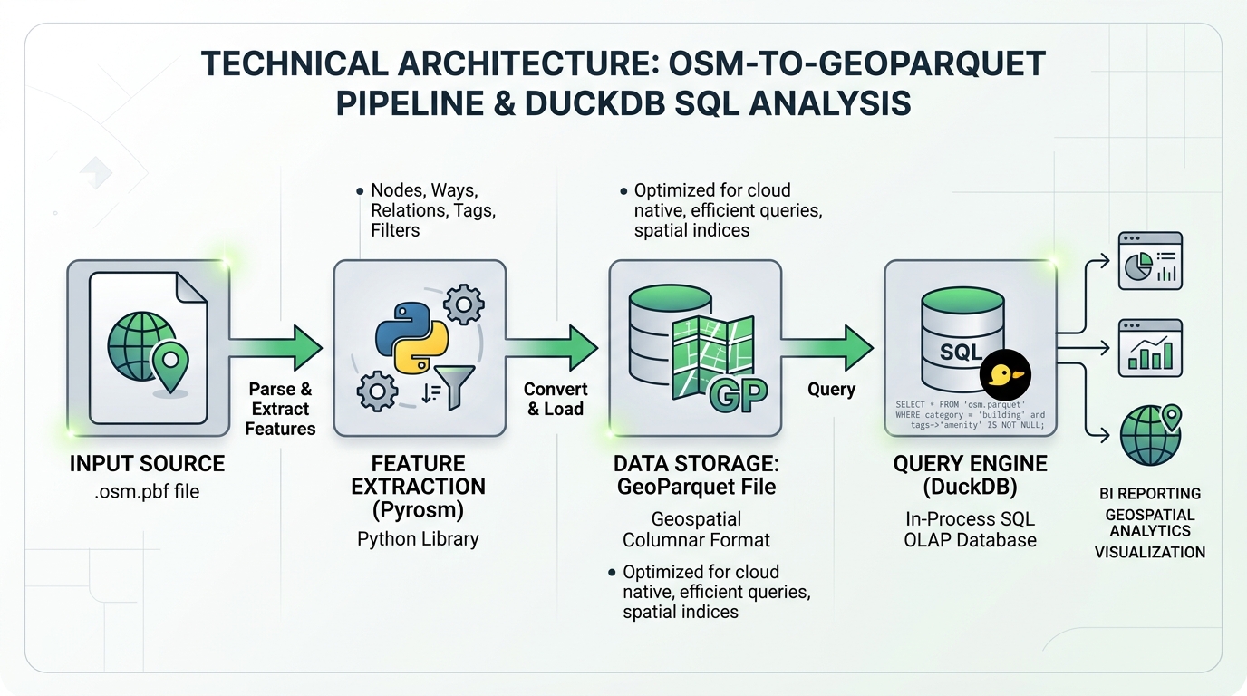
Query OpenStreetMap Data Python DuckDB performance comparison using DuckDB spatial SQL and GeoParquet

Querying OpenStreetMap Data at Scale with Python and DuckDB 1. Introduction: Why Combine OpenStreetMap with DuckDB? To Query OpenStreetMap Data Python DuckDB effectively, regional extracts provide detailed, openly accessible geographic data covering roads, buildings, and amenities. OpenStreetMap (OSM) provides detailed, openly accessible geographic data covering roads, buildings, amenities, land use, and countless other geographic features. … Read more

Segment Anything Model (SAM) for Automated Building Extraction in QGIS

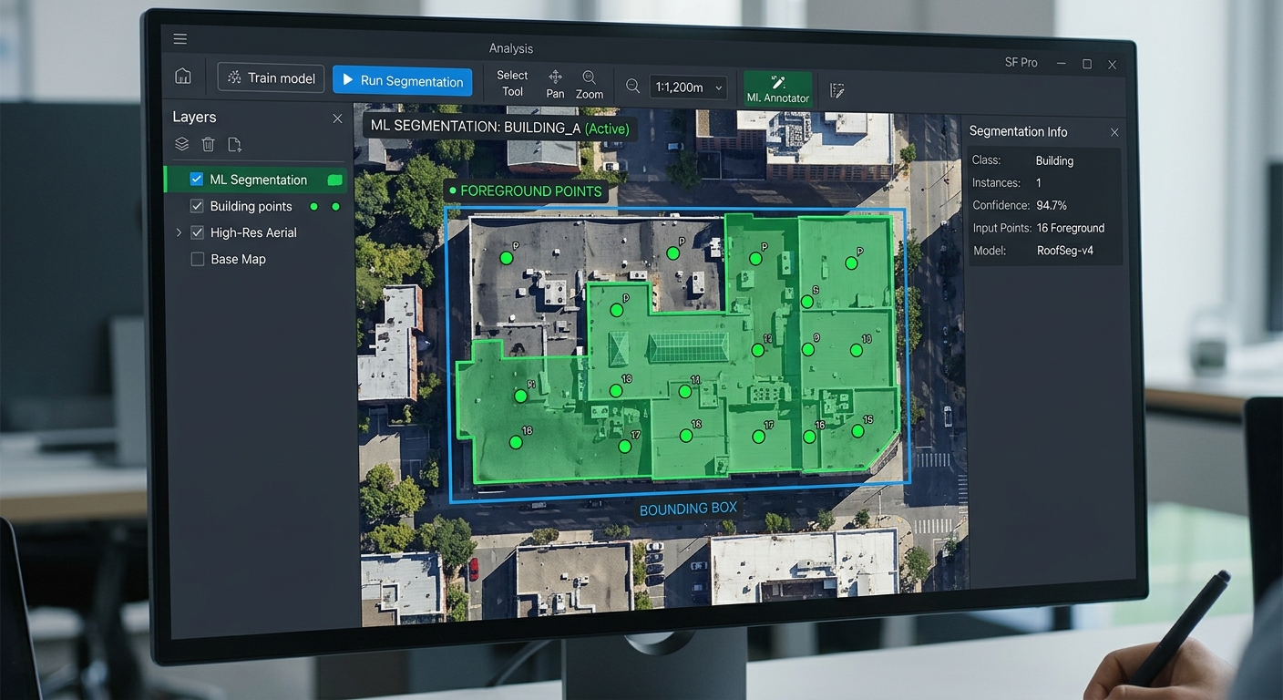
Segment Anything Model SAM QGIS building extraction point prompts and bounding boxes on a raster orthophoto

Segment Anything Model (SAM) for Automated Building Extraction in QGIS Introduction Using the Segment Anything Model SAM QGIS building extraction workflow significantly streamlines automated feature digitizing and spatial analysis compared to manual vector tracing. Building footprint extraction is one of the most time-consuming tasks in remote sensing and GIS. In conventional workflows, an analyst examines … Read more

Building Offline-First Field Collection Web Apps with Progressive Web App (PWA) Architecture

Offline First Field Collection Web App PWA GIS interface displayed on a rugged tablet during field data collection

Building Offline-First Field Collection Web Apps with Progressive Web App (PWA) Architecture Introduction “Implementing an Offline First Field Collection Web App PWA GIS is essential when field data collection takes place where internet connectivity is unreliable or unavailable. Field data collection frequently takes place where internet connectivity is unreliable or unavailable. Environmental surveys, agricultural assessments, … Read more

Spatial Regression with R: Fitting Spatial Lag and Spatial Error Models in spdep

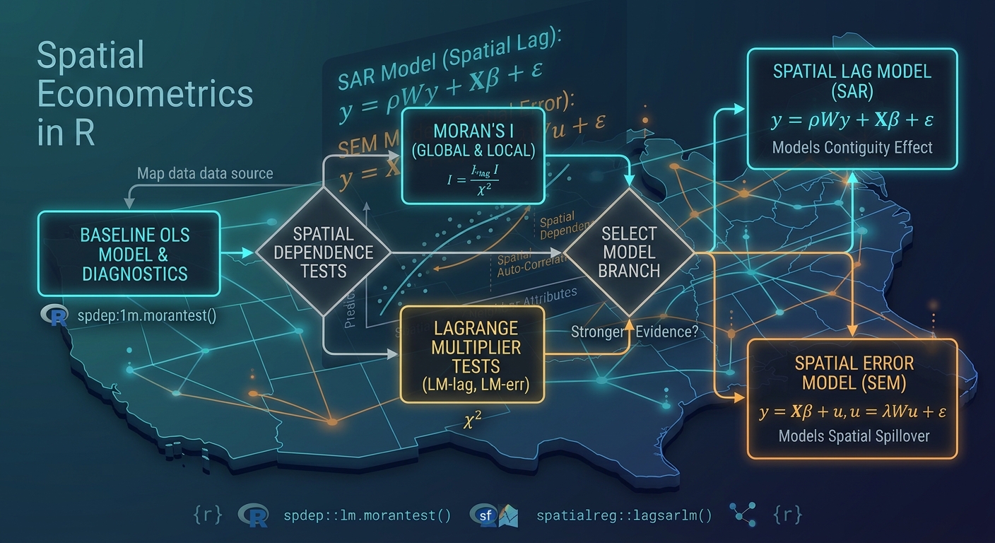
Spatial Regression with R spdep architecture chart comparing OLS, spatial lag, and spatial error models

Spatial Regression with R: Fitting Spatial Lag and Spatial Error Models in spdep Introduction When performing spatial regression with R spdep, Ordinary Least Squares (OLS) is often the natural starting point for regression analysis. Ordinary Least Squares (OLS) is often the natural starting point for regression analysis. In a conventional linear model, we assume that … Read more

Managing Large Geospatial Datasets Locally with DuckDB and the Spatial Extension

DuckDB Spatial Extension Large Datasets GIS benchmark chart illustrating fast spatial join execution

Managing Large Geospatial Datasets Locally with DuckDB and the Spatial Extension Introduction Large geospatial datasets can expose the limitations of conventional desktop GIS workflows. Opening a multi-gigabyte vector file may involve parsing geometry, decoding attributes, building rendering structures, and loading data into memory before an analyst can begin meaningful exploration. When a project contains millions … Read more

Extracting Building Footprints from Aerial Imagery Using OpenCV and Python

Extracting Building Footprints OpenCV Python visualization showing Canny edge detection and contour extraction

Extracting Building Footprints from Aerial Imagery Using OpenCV and Python 1. Introduction Mastering the fundamentals of extracting building footprints OpenCV Python offers a practical way to automate part of the building-mapping workflow before investing in deep learning models. Extracting building footprints with OpenCV and Python GIS tools offers a practical way to automate part of … Read more