
Spatial Window Functions and Recursive CTEs in PostGIS

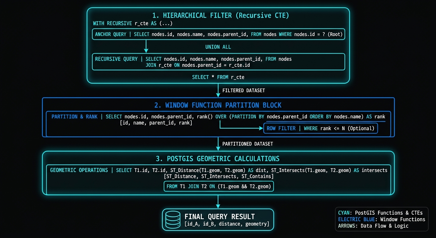
Spatial Window Functions Recursive CTEs PostGIS architecture showing trajectory and hierarchy workflows

Spatial Window Functions and Recursive CTEs in PostGIS Introduction Complex spatial analysis in PostgreSQL rarely requires abandoning SQL for procedural code. By combining PostgreSQL’s analytical SQL features with PostGIS geometry functions, it is possible to build sophisticated workflows for trajectory analysis, spatial hierarchies, network-like traversals, and sequential geographic processes entirely inside the database. Two SQL … Read more

Automated Metadata Generation and ISO Standards Compliance with Python

Developer workspace setting up Python packages for automated metadata generation Python pipelines

Automated Metadata Generation and ISO Standards Compliance with Python 1. Introduction Mastering Automated Metadata Generation Python scripts helps organizations transition from manual documentation to automated spatial data governance. Spatial data pipelines frequently produce valuable datasets without producing the metadata needed to understand, maintain, discover, or reuse them. A workflow may generate a road network, a … Read more

Multimodal Accessibility Modeling with GTFS Data in GIS

Multimodal Accessibility Modeling with GTFS Data in GIS 1. Multimodal Accessibility Modeling GTFS GIS: Understanding GTFS Data Conventional road network analysis answers questions such as how quickly a driver can travel between two locations, which roads provide the shortest route, or what area lies within a 15-minute drive. However, these methods do not adequately represent … Read more

Flood Risk Mapping with Synthetic Rating Curves and DEMs: A Practical GIS Tutorial

Flood Risk Mapping with Synthetic Rating Curves and DEMs: A Practical GIS Tutorial Introduction Flood risk mapping combines terrain analysis, river hydraulics, and hydrological frequency estimates to identify areas that may become inundated during high-flow events. A Digital Elevation Model (DEM) provides the terrain surface, while a river stage–discharge relationship, commonly called a rating curve, … Read more

Designing Accessible Maps for Color Vision Deficiencies (Colorblind-Safe Cartography)

Designing Accessible Maps for Color Vision Deficiencies (Colorblind-Safe Cartography) Introduction: Why accessible cartography matters Color is one of the most powerful visual variables in cartography. It helps readers distinguish geographic features, interpret quantitative patterns, identify boundaries, and recognize spatial relationships. However, a map that works well for a cartographer with typical color vision may be … Read more

How to Ace a Technical GIS Interview: Common Questions, Portfolios, and Coding Tests

How to Ace a Technical GIS Interview: Common Questions, Portfolios, and Coding Tests Introduction: What Hiring Managers Look for in Modern GIS Interviews Learning how to ace technical GIS interview questions coding test scenarios requires mastering more than just software—it demands a reliable problem-solving framework. A technical GIS interview is rarely just a test of … Read more

Building Real-Time Spatial Dashboards in QGIS with GeoNode and PostGIS

Building Real-Time Spatial Dashboards in QGIS with GeoNode and PostGIS Introduction: Why Static Maps Fall Short for Time-Sensitive Decisions A static map captures the state of a geographic area at a particular moment. That works well for printed reports, planning documents, and historical analysis, but it becomes less useful when the underlying situation changes every … Read more

Cross-Validation in Spatial Interpolation: How to Test Accuracy (IDW vs Kriging)

Cross-Validation in Spatial Interpolation: How to Test Accuracy (IDW vs Kriging) 1. Introduction: Why Spatial Interpolation Needs Validation Spatial interpolation transforms discrete sample measurements into continuous geographic surfaces. Environmental scientists use it to estimate groundwater levels, GIS analysts map air pollution, and agricultural researchers predict soil properties between sampling locations. However, a visually smooth raster … Read more

Fuzzy Logic in GIS Site Suitability: Moving Beyond Binary Constraints

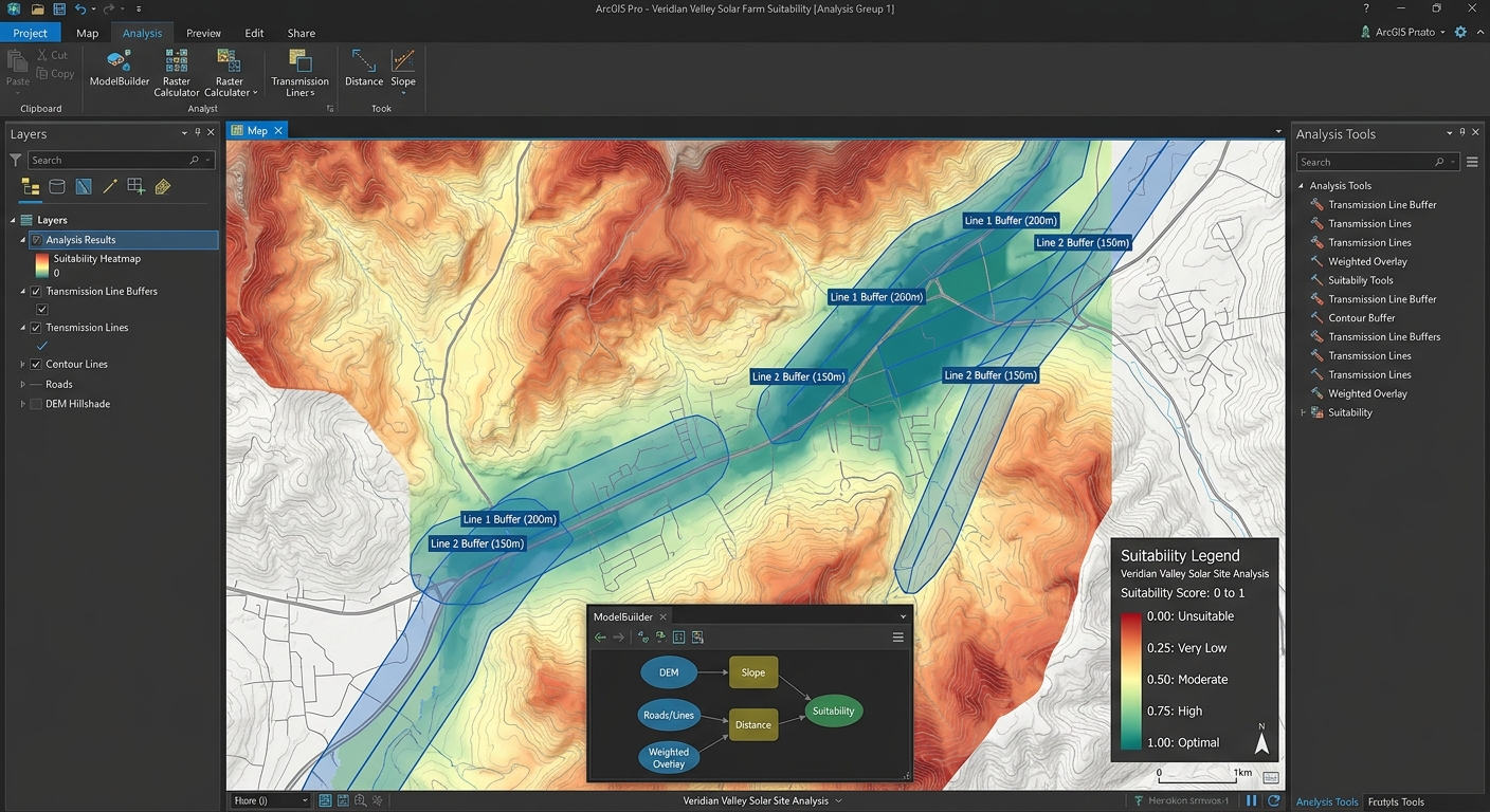
Continuous Suitability Surface Map for Solar Farm Site Selection

Fuzzy Logic in GIS Site Suitability: Moving Beyond Binary Constraints Introduction Traditional GIS site suitability analysis often relies on Boolean logic, where every location is classified as either suitable (1) or unsuitable (0). This approach is straightforward and easy to implement, but it can oversimplify geographic reality. Consider a hospital site-selection rule requiring a location … Read more

Building Custom QGIS Plugins with Python: A Beginner’s Guide

Building Custom QGIS Plugins with Python: A Beginner’s Guide PyQGIS Development Tutorial · QGIS Desktop · Python · Qt Designer Introduction Building a custom QGIS plugin with Python and PyQGIS allows GIS professionals to transform repetitive geospatial workflows into reusable tools. Instead of manually repeating the same sequence of geoprocessing operations, a team can develop … Read more