How to Calculate NDVI in QGIS: 10 Easy Steps

How to Calculate NDVI in QGIS: A Step-by-Step Guide for Students If you are learning how to calculate NDVI in QGIS, you are working with one of the most widely used vegetation indices in remote sensing. The Normalized Difference Vegetation Index (NDVI) uses the relationship between Near Infrared (NIR) and Red wavelengths to estimate the … Read more

Spatial Data vs Non Spatial Data: 5 Essential Key Differences

Spatial Data vs Non Spatial Data: 5 Key Differences Every GIS Student Should Know When comparing spatial data vs non spatial data, spatial data describes where something is located .Spatial data and non-spatial data are two fundamental geographic data types used in Geographic Information Systems (GIS). Spatial data describes where something is located and its … Read more

Vector vs Raster GIS: 7 Best Differences for Students

Vector vs. Raster Data: The Ultimate Cheatsheet for GIS Students   Vector vs Raster GIS: Why This Difference Matters When studying Vector vs Raster GIS, one of the first decisions that can feel confusing is whether your data should be represented as points, lines, and polygons or as a grid made up of pixels. Why … Read more

Spatial Join and Buffer Analysis in GIS: 5 Best Steps

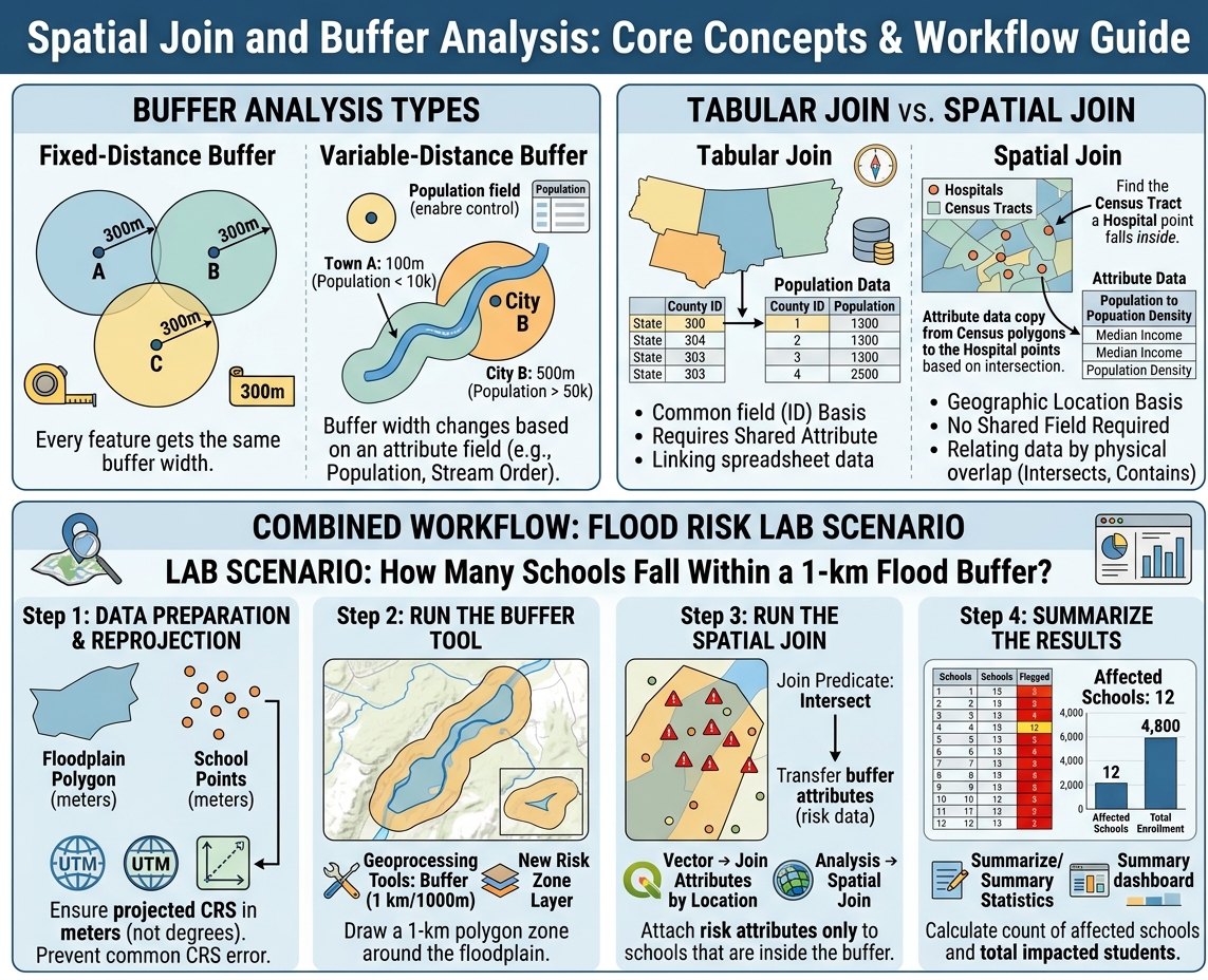
Spatial Join and Buffer Analysis workflow showing buffer types, spatial vs tabular join, and flood risk lab scenario

Demystifying Spatial Join & Buffer Analysis in GIS: A Beginner’s Guide Introduction Every GIS lab assignment eventually boils down to one of two questions: “What is near this?” and “What overlaps or falls inside this?” Answering the first question is the job of buffer analysis. Answering the second is the job of spatial joins. Together, … Read more

Geographic vs Projected CRS: 5 Best Differences for Students

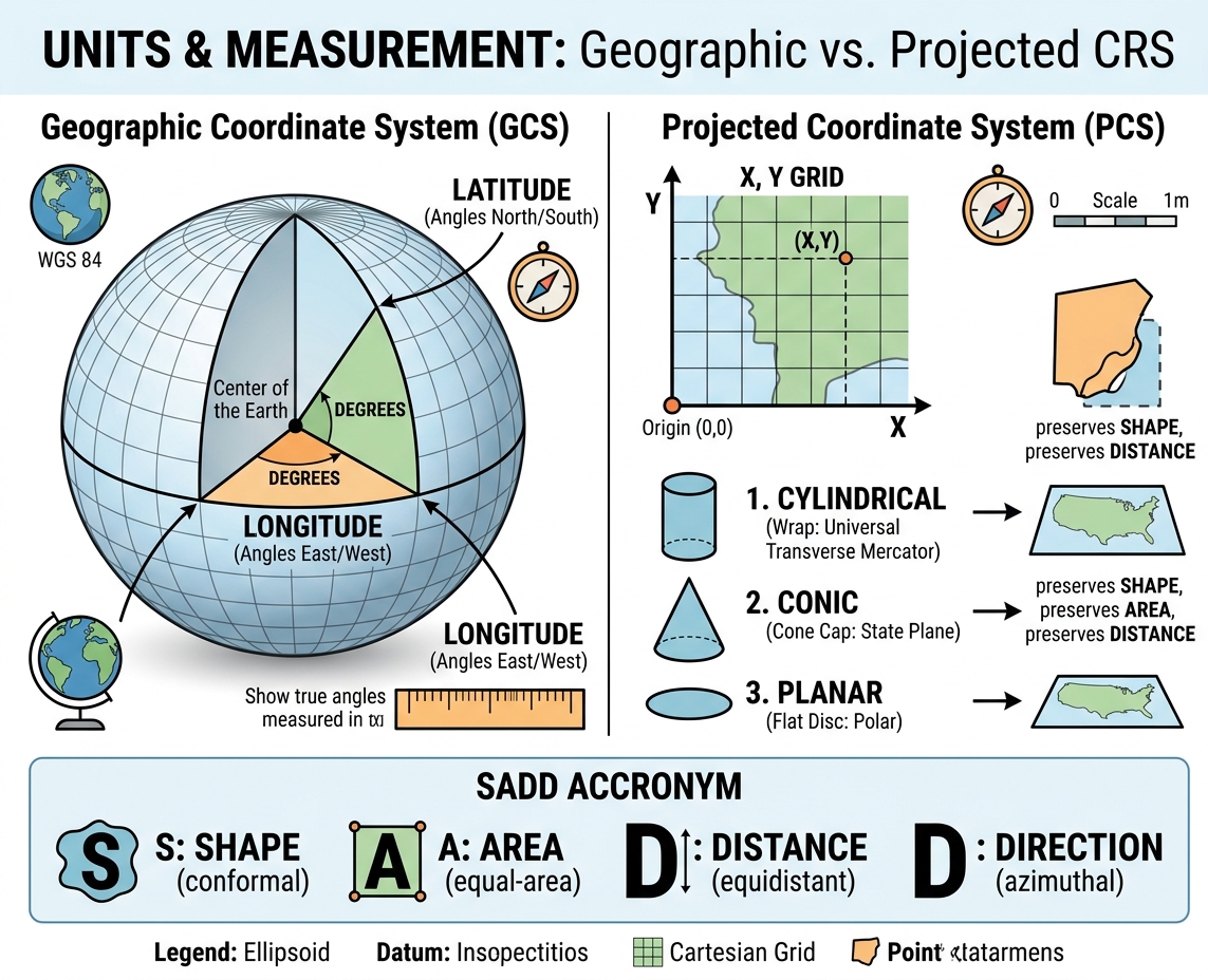
GIS infographic comparing Geographic (3D angles) vs. Projected (2D linear) CRS, showing map projection developable surfaces and SADD distortion trade-offs.

Geographic vs. Projected Coordinate Reference Systems (CRS) Explained Simply Introduction: The Orange Peel Dilemma When studying Geographic vs Projected CRS, imagine peeling an orange in one continuous piece and trying to lay that curved peel completely flat on a table without stretching or tearing it—it is physically impossible. This classic orange peel analogy illustrates the … Read more

GIS in Urban Planning: 5 Best Applications for Students

GIS in Urban Planning & Smart Cities: Coursework, Applications & Project Ideas Introduction When applying GIS in Urban Planning, modern cities must be analyzed as complex spatial systems where housing, roads, public transport, and utilities compete for limited land. For urban planners and civil engineers, understanding where something happens is just as important as understanding … Read more

GIS in Flood Modeling: 7 Essential Steps for Environmental Risk Assessment

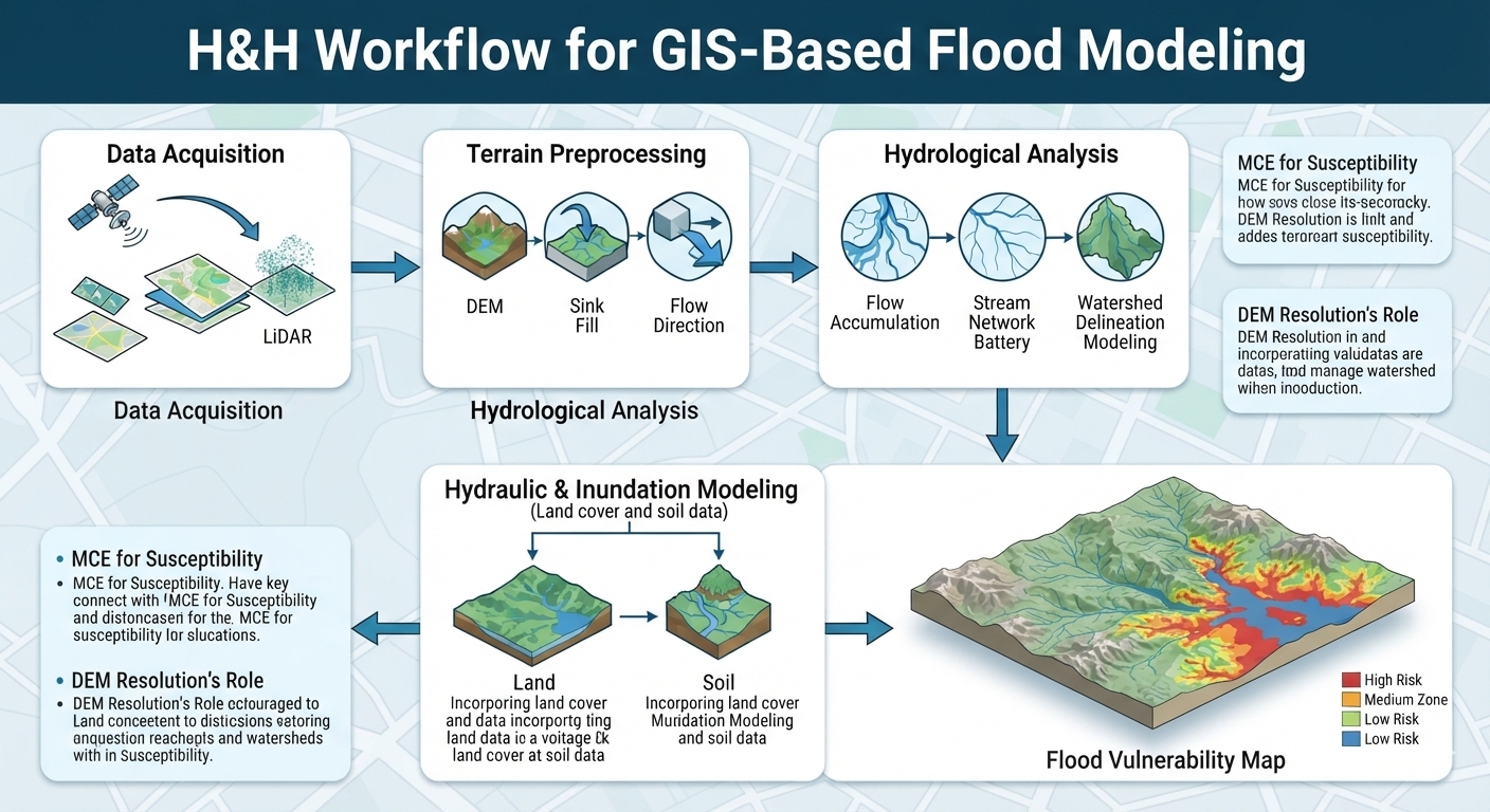
GIS in Flood Modeling H&H workflow flowchart showing elevation processing, hydrological analysis, and risk mapping

How GIS is Used in Environmental Risk & Flood Modeling: A Student Guide Introduction Flooding is one of the most significant natural hazards affecting communities, infrastructure, agriculture, and ecosystems. Changes in precipitation patterns, rapid urbanization, vegetation loss, and development in flood-prone areas can increase the consequences of extreme rainfall events. GIS in Flood Modeling provides … Read more

5 Best Free GIS Data Sources for University Projects (2026)

Top 5 Free GIS Data Sources for University Projects   If you have ever spent three hours hunting for a usable GIS dataset only to discover that it is outdated, poorly documented, or locked behind a confusing download portal, you are not alone. For university GIS assignments, the difficult part is often finding reliable raw … Read more

5 Proven Tips to Fix Unknown Coordinate System Errors in ArcGIS & QGIS

Fixing “Unknown Coordinate System” Errors in ArcGIS & QGIS (Layers Not Aligning) Quick Diagnosis If your layers are scattered across the map instead of stacking correctly, your data is almost certainly missing its coordinate system information — the .prj file or embedded metadata header that tells the software where on Earth the data actually is. … Read more