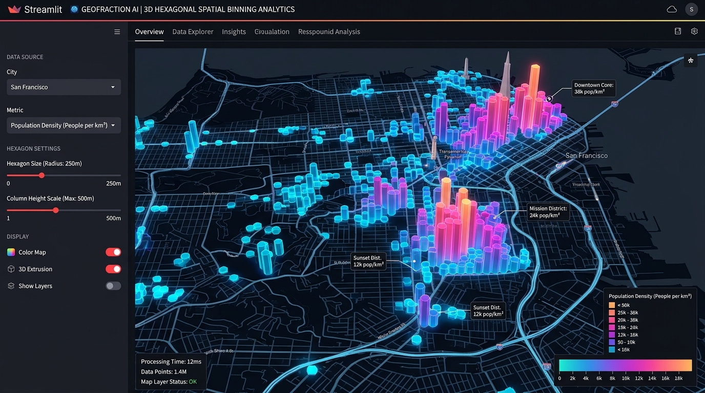
Building Interactive Spatial Analytics Dashboards in Python with Streamlit and PyDeck

Streamlit PyDeck spatial analytics dashboards 3D hexagon aggregation and column extrusion layer

Building Interactive Spatial Analytics Dashboards in Python with Streamlit and PyDeck Streamlit PyDeck spatial analytics dashboards bridge the gap between heavy desktop GIS software and custom web application development, allowing data scientists to prototype and deploy high-performance 3D spatial visualizations entirely in Python. Data scientists and geospatial analysts frequently face a frustrating architectural bottleneck: transforming … Read more

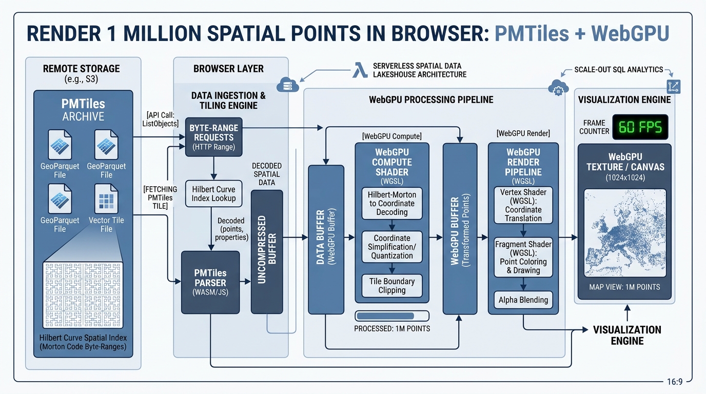
Rendering 1 Million Spatial Points in the Browser using PMTiles and WebGPU

System architecture diagram illustrating Rendering 1 Million Spatial Points in the Browser using PMTiles and WebGPU

Rendering 1 Million Spatial Points in the Browser using PMTiles and WebGPU Introduction Rendering 1 Million Spatial Points in the Browser has historically caused severe performance degradation until the introduction of modern hardware-accelerated web graphics. Rendering massive vector datasets containing over one million point features in an interactive web browser map has historically triggered severe … Read more

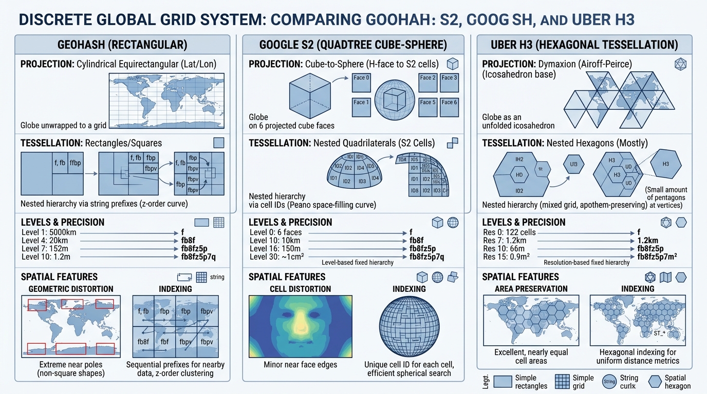
H3 Spatial Indexing vs. Geohash vs. S2: Choosing the Right Discrete Global Grid System (DGGS)

System architecture diagram illustrating Spatial Indexing vs Geohash vs S2 and DGGS performance metrics

H3 Spatial Indexing vs. Geohash vs. S2: Choosing the Right Discrete Global Grid System (DGGS) Introduction When evaluating Spatial Indexing vs Geohash vs S2, modern data architectures must balance spatial precision with computational scalability. In modern big data analytics and distributed geospatial systems, handling spatial data via traditional computational geometry algorithms—such as arbitrary bounding box … Read more

Spatial Window Functions in PostGIS: Analyzing Spatio-Temporal Trajectories and Moving Objects

Spatial Window Functions in PostGIS: Analyzing Spatio-Temporal Trajectories and Moving Objects Introduction Tracking moving entities—whether commercial delivery fleets, migrating wildlife, marine vessels, or cellular devices—generates massive, high-frequency streams of coordinate fixes known as trajectories. In enterprise GIS and spatial database administration, raw GPS pings are notoriously noisy, unordered, and difficult to interpret without context. Traditional … Read more

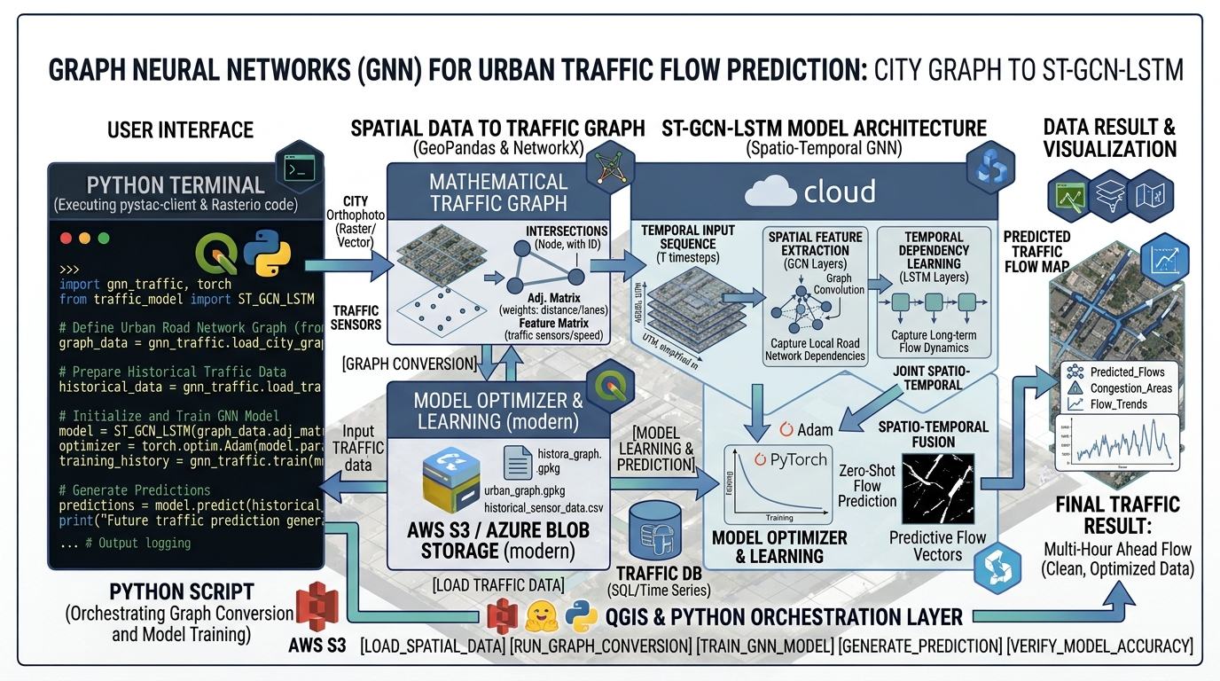
Graph Neural Networks (GNNs) for Urban Traffic Flow and Spatial Network Prediction

System architecture diagram illustrating Graph Neural Networks Urban Traffic Flow and spatial network prediction

Graph Neural Networks (GNNs) for Urban Traffic Flow and Spatial Network Prediction Introduction Implementing Graph Neural Networks Urban Traffic Flow forecasting transforms how modern intelligent transportation systems predict congestion bottlenecks and spatial dependencies. Traditional time-series forecasting frameworks—such as Autoregressive Integrated Moving Average (ARIMA), Seasonal Decomposition of Time Series (STL), and standard Recurrent Neural Networks (RNNs) … Read more

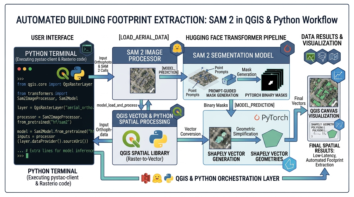
Automated Building Footprint Extraction using Segment Anything Model 2 (SAM 2) in QGIS and Python

SAM 2 Building Footprint Extraction QGIS Python

Automated Building Footprint Extraction using Segment Anything Model 2 (SAM 2) in QGIS and Python Introduction Implementing SAM 2 Building Footprint Extraction QGIS Python pipelines allows geospatial analysts and data scientists to achieve state-of-the-art vector extraction without training custom neural networks from scratch. In the rapidly evolving domain of Geographic Information Systems (GIS) and Remote … Read more

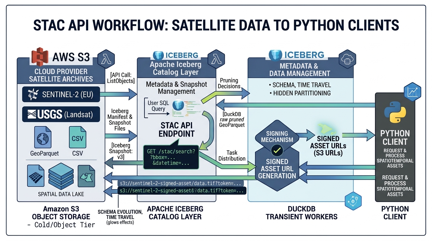
STAC (SpatioTemporal Asset Catalog) API Specification: Automating Satellite Data Pipelines

System architecture diagram illustrating the STAC API Specification workflow for satellite data pipelines

STAC (SpatioTemporal Asset Catalog) API Specification: Automating Satellite Data Pipelines Introduction Building Vector Tile Servers with Martin PostGIS allows modern web mapping applications to render millions of spatial records smoothly without client-side performance bottlenecks.Global satellite archives are distributed across multiple data providers, storage systems, and access interfaces. Sentinel imagery is available through Copernicus services and … Read more

Building a Serverless Spatial Data Lakehouse with GeoParquet, Apache Iceberg, and DuckDB

Building a Serverless Spatial Data Lakehouse with GeoParquet, Apache Iceberg, and DuckDB Introduction When building a Serverless Spatial Data Lakehouse GeoParquet DuckDB stack, geospatial data engineering is increasingly concerned with datasets too large, too frequently updated, or too geographically distributed for conventional database architectures to handle efficiently. Geospatial data engineering is increasingly concerned with datasets … Read more

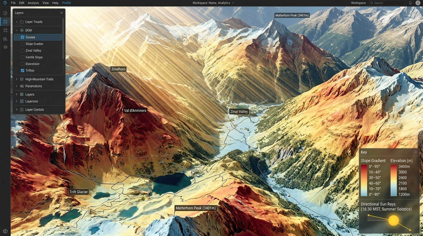
3D Solar Radiation Modeling on Complex Terrain Using DEMs and GRASS GIS

3D solar radiation modeling DEM terrain preparation and horizon obstacle analysis

3D Solar Radiation Modeling on Complex Terrain Using DEMs and GRASS GIS Utility-scale solar photovoltaic (PV) deployment has expanded from flat, arid plains into complex, mountainous topographies. Estimating solar yield across rugged landscapes presents significant spatial modeling challenges: standard planar insolation models fail to account for microclimatic fluctuations, terrain-induced self-shadowing, elevated horizon obstructions, and anisotropic … Read more