
How to Publish Free Interactive Maps with qgis2web and GitHub Pages

Introduction: How to Publish Free Interactive Maps with qgis2web and GitHub Pages
qgis2web plugin solves this by translating your QGIS layers, symbology, and attribute tables directly into web-ready code (HTML, CSS, and JavaScript via Leaflet or OpenLayers). Combined with GitHub Pages, which provides free static web hosting straight from a code repository, you get a zero-cost infrastructure to deploy professional, browser-based maps accessible anywhere in the world.Step 1: Preparing Your Map in QGIS
-
Clean Layer Names: Rename your layers in the Layers panel. The names you use here will automatically populate your web map’s layer switcher list (avoid special characters and spaces if possible, using underscores or clean title case instead).
-
Configure Pop-up Attributes: By default, clicking a feature in your web map will display its attribute data. Open your vector layer Properties > Fields, and set unnecessary ID fields to “Hidden” or configure friendly aliases so your users see clean, readable labels instead of raw database columns.
-
Optimize Symbology & CRS: Keep complex vector geometries reasonably simplified to reduce load times. Ensure your project is set to a web-friendly Coordinate Reference System (CRS) such as EPSG:3857 (WGS 84 / Pseudo-Mercator), which is standard for web mapping libraries like Leaflet.
Step 2: Configuring the qgis2web Plugin
-
Install the Plugin: If you haven’t already, open QGIS and go to Plugins > Manage and Install Plugins. Search for
qgis2weband click Install Plugin. -
Open the Exporter: Navigate to Web > qgis2web > Create web map. A configuration panel will dock on the right side of your screen.
-
Choose Your Mapping Library:
-
Under the exporter options, choose between Leaflet (recommended for lightweight, mobile-friendly maps with extensive plugin ecosystems) and OpenLayers (ideal for heavy enterprise datasets or advanced spatial operations).
-
-
Configure Interactive Widgets:
-
Layers list: Check this to let users toggle individual vector and raster layers on or off.
-
Popups: Select whether feature information appears on Hover or Click. “Click” is usually best for touchscreens and detailed data inspection.
-
Search bar: Enable the search widget to let users look up features by attribute fields (e.g., searching for a city name or parcel ID).
-
Appearance: Set your map canvas dimensions, add a scale bar, and choose a clean web basemap (such as OpenStreetMap or CartoDB Positron) to sit underneath your custom layers.
-
-
Preview the map directly within the dialog box to check your styling and layer behavior before exporting.
Step 3: Exporting the Web Map Package
-
Click the Export button at the bottom of the qgis2web panel.
-
Designate an empty folder on your local computer to save the export package.
-
The plugin will generate a self-contained directory containing:
-
An
index.htmlfile (your main application entry point). -
A
css/folder with stylesheet files. -
A
js/folder housing the Leaflet/OpenLayers scripts and data files (often stored as GeoJSON or JS arrays). -
A
images/orlayers/folder containing your custom markers and spatial data.
-
-
Double-click the
index.htmlfile to test it locally in your web browser and confirm everything functions correctly.
Step 4: Hosting on GitHub Pages
Step 5: Testing Your Live Public URL
https://<your-username>.github.io/<repository-name>/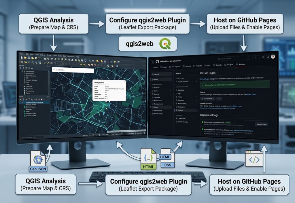
Conclusion & Next Steps for Student Portfolios
qgis2web, and deploying via GitHub Pages, you can rapidly prototype and broadcast geospatial stories.index.html file to customize the header title, tweak CSS styles, or integrate external widgets like custom legends and charts. Ultimately, mastering How to Publish Free Interactive Maps with qgis2web and GitHub Pages is an essential skill for modern geospatial portfolios.Frequently Asked Questions
How do I update my map after publishing it?
If you need to make changes to your layers or styling, simply re-run the qgis2web export in QGIS to overwrite your local files. Then, go to your GitHub repository, upload the updated files, and commit the changes. GitHub Pages will automatically refresh your live site within a few minutes.
Is it completely free to learn How to Publish Free Interactive Maps with qgis2web and GitHub Pages?
Yes! Both QGIS and GitHub offer free tiers and open-source licenses, allowing you to build, host, and share unlimited web maps for your professional portfolio without any subscription costs or hidden hosting fees.
Can I customize the code after exporting?
Absolutely. Once you export your project package, you can open the generated `index.html` file or look inside the `css/` and `js/` folders using any text editor to fine-tune your popup styles, add custom headers, or integrate external widgets.