
Dissolve vs Merge vs Union GIS Guide: Which Vector Tool Should You Use?
Choosing the right geoprocessing tool in software like QGIS or ArcGIS Pro can easily make or break your spatial analysis. When working on a vector analysis lab or putting together a comprehensive GIS assignment, combining spatial features is one of the most fundamental operations you will perform. However, three tools frequently cause widespread confusion among students: Dissolve, Merge, and Union.
While all three functions group or combine vector features into a consolidated dataset, they rely on completely different underlying geometric and topological logic.
Selecting the wrong tool doesn’t just result in an ugly map—it corrupts attribute tables, calculates incorrect spatial statistics, and leads to wrong conclusions in your lab reports.
This visual decision guide breaks down dissolve vs merge vs union GIS operations step-by-step so you can confidently select the exact tool your coursework demands.
1. Dissolve: Aggregating Boundaries Within a Single Layer
Definition
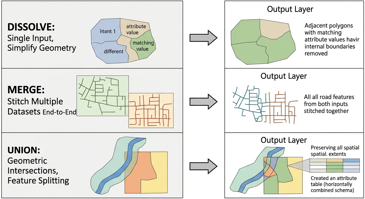
The Dissolve tool aggregates adjacent or overlapping features within a single vector layer based on a shared attribute value. It removes internal boundaries (lines or polygon borders) between features that share identical values in a specified field.When comparing dissolve vs merge vs union GIS operations, Dissolve is unique because it works strictly on a single input layer.
Input Requirements & Mechanics
-
Input Layers: Exactly one vector layer (Polygons or Lines).
-
Geometry Restrictions: Works on single-part or multi-part vector features.
-
Core Logic: Dissolve looks down a specific column in your attribute table. Wherever two adjacent polygons share the exact same value in that column, the tool erases the border separating them and merges them into a single, unified feature.
Attribute Aggregation Rules
When boundaries disappear, multiple attribute rows are collapsed into one. To prevent data loss during your GIS assignment workflows, you must define aggregation statistics (e.g.,
SUM, MEAN, COUNT, MIN, MAX) for numerical fields. For instance, if you dissolve county polygons, you can instruct the tool to sum their population fields so the resulting state polygon contains the total population.+------------------+------------------+ Dissolve on +------------------------------------+
| County A (Pop: 10)| County B (Pop: 15)| 'State_ID' = 'ST1' | State ST1 |
| State_ID: ST1 | State_ID: ST1 | --------------------> | (Internal boundary removed) |
+------------------+------------------+ Sum(Pop) = 25 | Total Pop: 25 |
Real-World Student Assignment Example
Suppose your assignment asks you to create a regional state boundary map using individual county-level shapefiles.
-
You select the county shapefile as your single input layer.
-
You choose
State_Nameas your Dissolve Field. -
The tool erases all county lines inside each state, leaving you with clean state outlines while calculating total regional population via field aggregation rules.
2. Merge: Combining Datasets End-to-End
Definition
The Merge tool combines two or more separate vector datasets into a single output dataset without altering, splitting, or intersecting their underlying geometries.Unlike overlay methods in dissolve vs merge vs union GIS workflows, Merge does not alter geometries or split lines.
Input Requirements & Mechanics
-
Input Layers: Two or more distinct vector layers.
-
Geometry Restrictions: All input layers must share the same geometry type (e.g., Point with Point, Line with Line, Polygon with Polygon). You cannot merge a point layer with a polygon layer.
-
Core Logic: Merge works like copy-pasting records from multiple spreadsheets into one master sheet. The features sit side-by-side in space. If features overlap spatially, Merge does not cut or split them; it simply stacks them on top of each other as separate features.
Schema Matching & Field Mapping
Because you are combining separate files, their attribute tables (schemas) might not match perfectly.
-
Matching Fields: Fields with identical names and data types across input files are automatically appended into single columns.
-
Unmatched Fields: Fields present in File A but absent in File B are retained in the output, but features originating from File B will show
NULLor blank values in those columns.
Layer A (Roads North): [ID, Road_Name, Speed_Limit]
Layer B (Roads South): [ID, Road_Name, Surface_Type]
                     │
                     ▼ (MERGE TOOL)
Output Layer:          [ID, Road_Name, Speed_Limit, Surface_Type]
                       └─ Features from B have NULL Speed_Limit
                       └─ Features from A have NULL Surface_Type
Real-World Student Assignment Example
Imagine your professor gives you four separate road network shapefiles corresponding to North, South, East, and West quadrants of a city. To perform network routing across the entire city:
-
You run the Merge tool using all four quadrant shapefiles as inputs.
-
The tool outputs a single, seamless road layer containing all line segments.
-
No street lines are cut or broken; their attribute tables are cleanly combined into one dataset.
Properly executing these workflow steps prevents errors when applying a dissolve vs merge vs union GIS strategy to your dataset.
3. Union: Geometric Overlays and Intersections for Polygons
Definition
The Union tool calculates the geometric intersection of two or more polygon layers, splitting overlapping areas into new features and preserving all spatial extents and attributes from every input. When your project demands overlaying spatial boundaries, mastering a dissolve vs merge vs union GIS comparison is critical for accurate results. In terms of dissolve vs merge vs union GIS polygon operations, Union is the most comprehensive overlay tool.
Input Requirements & Mechanics
-
Input Layers: Two or more vector layers.
-
Geometry Restrictions: Polygons ONLY. Union does not accept point or line features.
-
Core Logic: Union is a classic overlay tool (a Boolean
ORoperation). It slices polygon boundaries wherever input layers overlap. The output contains:-
Areas belonging exclusively to Layer A.
-
Areas belonging exclusively to Layer B.
-
Overlapping areas belonging to both Layer A and Layer B.
-
       Layer A (Flood Zone)                Layer B (Zoning)
         +---------------+                 +---------------+
         |               |                 |               |
         |       +-------+-------+         |               |
         |       |  A    |   A+B |         |               |
         +-------+-------+       |         +---------------+
                 |       B       |
                 +---------------+
                         │
                         ▼ (UNION OVERLAY)
Output: 3 distinct polygon features generated with full attribute preservation.
Attribute Preservation
Unlike Dissolve (which aggregates attributes) or Merge (which stacks rows), Union combines attribute fields horizontally. Where Layer A and Layer B overlap, the output feature receives all attribute columns from Layer A AND all attribute columns from Layer B. In non-overlapping zones, fields from the absent layer are populated with
NULL values.Real-World Student Assignment Example
In an environmental planning GIS assignment, you are tasked with identifying residential parcels located inside a 100-year flood zone:
-
Input 1: City Residential Zoning Polygons.
-
Input 2: 100-Year Flood Plain Polygons.
-
Running Union creates a new layer where parcels intersecting the flood zone are cut into distinct sub-polygons. You can instantly query features that carry both
Zone_Type = 'Residential'ANDFlood_Risk = 'High'.
4. Dissolve vs Merge vs Union GIS Decision Matrix
Use this reference table when completing lab reports or reviewing vector geoprocessing tools for exams:
| Feature / Criteria | Dissolve | Merge | Union |
| Input Layers Required | Exactly 1 layer | 2 or more layers | 2 or more layers |
| Allowed Geometry Types | Points, Lines, or Polygons | Same geometry across inputs (Point/Line/Polygon) | Polygons ONLY |
| Modifies Feature Boundaries? | Yes (erases internal borders between matching attributes) | No (preserves original geometries as-is) | Yes (splits polygons at all intersection boundaries) |
| Attribute Table Behavior | Collapses rows; relies on aggregation functions (Sum, Mean) | Appends rows vertically; populates unmatched fields with NULL |
Combines columns horizontally; joins all fields across inputs |
| Primary GIS Analysis Purpose | Simplifying maps, generalizing data, removing administrative borders | Combining tiled datasets or adjacent spatial files | Multi-criteria evaluation, land-use overlay, suitability analysis |
| Common Software Location |
QGIS: Vector > Geoprocessing Tools
ArcGIS Pro: Analysis > Tools > Dissolve
|
QGIS: Vector > Data Management Tools
ArcGIS Pro: Data Management > General
|
QGIS: Vector > Geoprocessing Tools
ArcGIS Pro: Analysis > Tools > Union
|
5. How to Choose Between Dissolve vs Merge vs Union GIS Tools
When working through complex vector analysis tasks, use this 3-step decision workflow to choose the correct tool:
                  [ START: GIS Assignment Task ]
                                │
                                ▼
               How many input layers do you have?
                                │
       ┌────────────────────────┴────────────────────────┐
       ▼                                                 ▼
[ EXACTLY ONE LAYER ]                            [ MULTIPLE LAYERS ]
       │                                                 │
       ▼                                                 ▼
Do you need to simplify                       Do features overlap and
boundaries using an attribute?                require geometric slicing?
       │                                                 │
       ├──► YES: Use DISSOLVE                            ├──► YES: Use UNION (Polygons only)
       │                                                 │
       └──► NO: Re-check lab steps                       └──► NO: Do you want to combine tile datasets
                                                                  of the same geometry side-by-side?
                                                                         │
                                                                         └──► YES: Use MERGE
Step 1: Count Your Input Datasets
-
If your lab instructions give you a single dataset (e.g., a national soil map) and ask you to simplify it based on soil class, use Dissolve.
-
If you have two or more datasets, move to Step 2.
Step 2: Determine Geometric Interaction Needs
-
If your goal is simply to stitch adjacent spatial tiles together end-to-end (e.g., county road shapefiles) without modifying feature shapes, use Merge.
-
If your layers overlap spatially and you need to calculate spatial interactions or combined attributes, move to Step 3.
Step 3: Check Geometry and Topological Slicing
-
If you must slice overlapping polygons to analyze combined spatial properties (e.g., overlaying habitat maps with land ownership boundaries), use Union.
-
Note: If you need to combine overlapping layers but only want to keep areas where both layers overlap (rather than all areas), consider using the Intersect tool instead of Union.
Conclusion: Protecting Your Data Integrity
Selecting between Dissolve, Merge, and Union comes down to understanding your input layers, geometry constraints, and attribute table goals:
-
Use Dissolve to aggregate and simplify single layers based on field values.
-
Use Merge to stitch multiple matching datasets into a single file without altering shapes.
-
Use Union to perform polygon overlay analyses that cut geometries and combine attribute fields.
Before submitting your lab report, open your output layer’s attribute table. Check for unexpected
NULL values, verify feature counts, and ensure field aggregation values match your mathematical expectations. Mastering these vector geoprocessing tools ensures clean spatial workflows, accurate statistical outputs, and top-tier grades on every GIS assignment.