
Shapefile vs. GeoPackage vs. File Geodatabase: Which Format Should You Use?
1. Introduction: The Evolution of GIS Data Storage
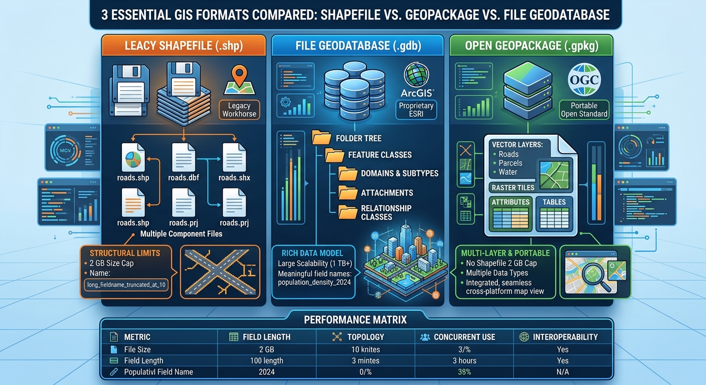
Understanding Shapefile vs GeoPackage vs File Geodatabase GIS criteria is essential because choosing the right spatial data format is a fundamental decision in any GIS project. Choosing the right spatial data format is an important decision in any GIS project. A format determines how geographic features and their attributes are stored, how easily data can be exchanged between applications, and which relationships and data types can be preserved.
For many years, the ESRI Shapefile (.shp) was the standard choice for exchanging vector data. Its simplicity, widespread software support, and straightforward structure made it useful for university assignments, government mapping, environmental research, and land administration.
However, the Shapefile was designed around an older data model. Modern GIS projects often require longer field names, multiple related layers, larger datasets, richer attributes, and more reliable data management. These demands have encouraged analysts to adopt formats such as OGC GeoPackage (.gpkg) and Esri File Geodatabase (.gdb).
Both offer significant improvements over Shapefile, but they serve somewhat different purposes.
- Shapefile: A simple, widely supported interchange format with substantial structural limitations.
- GeoPackage: An open, standards-based database file suitable for portable GIS projects and open-source workflows.
- File Geodatabase: A scalable Esri-oriented geodatabase designed for richer GIS data models and workflows in ArcGIS.
This guide compares their capabilities, limitations, compatibility, and ideal use cases so you can choose the right format for academic research, environmental analysis, enterprise projects, and professional GIS development.
2. Deep Dive into the Three GIS Formats
2.1 Shapefile (.shp): The Legacy Workhorse
A Shapefile is a vector format originally developed by Esri. It stores feature geometry and attributes in separate, associated files.
A typical Shapefile dataset contains at least three required files:
| File extension | Purpose |
|---|---|
.shp |
Stores feature geometry |
.shx |
Stores the geometry index |
.dbf |
Stores the attribute table |
Additional files may include .prj for coordinate reference system information and .cpg for character encoding. Other optional files can store indexes or metadata.
This multi-file structure creates one of the format’s most familiar problems: a GIS dataset is not represented by the .shp file alone.
If you send a Shapefile to a colleague but forget the .dbf file, the geometry and attributes may no longer be accessible together. Forgetting the .prj file can also make its coordinate reference system unclear.
Key limitations of Shapefile
1. The 10-character field-name limit
Shapefile attribute field names are limited to 10 characters.
For example, a field named population_density may be truncated or renamed during export. This can make attribute tables difficult to understand, especially in demographic or environmental projects containing many variables.
2. The 2 GB file-size limit
Esri documents a 2 GB size limit for Shapefiles. Large polygon datasets, detailed road networks, and high-resolution vector outputs can approach this boundary.
Large datasets may need to be split into multiple files or stored in a more capable format.
3. Restricted attribute capabilities
Shapefiles use the older dBASE attribute format. This limits the available field types and restricts how data such as null values, long text, and other complex attributes can be represented.
4. No native relational data model
A Shapefile cannot natively provide the richer relationship classes, domains, and other database capabilities available in geodatabase formats.
5. Multiple files increase management overhead
Because a dataset consists of associated files, copying, renaming, uploading, and distributing it require more care. Even zipped Shapefiles must retain the necessary component files.
Esri’s official Shapefile documentation describes these constraints, including its 2 GB size limit and 10-character field-name restriction.
Advantages
- Supported by virtually all mainstream GIS applications.
- Simple to create, inspect, and distribute.
- Useful when a recipient specifically requires Shapefile output.
- Suitable for small, straightforward vector datasets.
Disadvantages
- 10-character field names can make attributes difficult to interpret.
- The 2 GB limit restricts large datasets.
- Multiple files must be kept together.
- Limited support for richer attribute types and relationships.
- Not ideal as the primary storage format for new, complex GIS projects.
Best use case: Exchanging simple vector datasets with organizations or legacy systems that specifically require Shapefiles.
2.2 Esri File Geodatabase (.gdb): The Structured GIS Data Store
A File Geodatabase is a folder-based data store designed around the Esri geodatabase data model. It can organize multiple feature classes, tables, and other supported GIS datasets within a single .gdb directory.
Unlike a Shapefile, a File Geodatabase is not limited to one collection of geometry and attribute files per layer. It provides structured storage and supports advanced geodatabase capabilities.
For example, a municipal planning project could store roads, parcels, schools, administrative boundaries, and non-spatial reference tables inside one File Geodatabase.
Key capabilities
1. Larger datasets
Esri specifies no overall File Geodatabase size limit, although individual tables and feature classes have their own limits.
The default maximum size of a feature class or table is 1 TB. Esri documents configuration options that can raise the limit to 4 GB or 256 TB per dataset, depending on the selected configuration keyword and use case.
Consequently, a File Geodatabase can support datasets far beyond the scale of a conventional Shapefile.
2. Longer field names
File Geodatabases support field names of up to 128 characters under Esri’s documented limits.
This permits meaningful names such as average_annual_rainfall, soil_organic_carbon, or population_density, making attribute tables easier to interpret.
3. Domains and subtypes
A File Geodatabase can enforce structured attribute values through attribute domains and organize features using subtypes.
For example, a road inventory could restrict the road_condition field to predefined categories, while a subtype field distinguishes primary roads, secondary roads, and access roads.
These capabilities improve consistency and reduce data-entry errors.
4. Relationship classes and attachments
File Geodatabases can represent relationships among feature classes and tables. They also support attachments, which allow files such as photographs or documents to be associated with geographic features.
A field survey dataset could therefore associate each sampled location with inspection photographs or a supporting report.
5. Efficient storage and geodatabase tools
File Geodatabases support spatial indexes, compression options, and geodatabase-specific data management tools. Their internal structures can be efficient for large vector datasets and ArcGIS workflows.
For complete feature and size details, see Esri’s File Geodatabase documentation and size and name limits.
Important limitation: It is not an enterprise multiuser database
A File Geodatabase offers many advanced GIS capabilities, but it should not be confused with an enterprise geodatabase backed by a client-server database management system.
Multiple clients can access a File Geodatabase simultaneously, but concurrent editing of the same dataset is restricted. File Geodatabases do not provide the same versioned, multi-editor workflows as enterprise geodatabases.
They are also managed as a collection of files inside a folder. You should not rename, move, or delete individual internal files manually. Operate on its datasets through appropriate GIS tools and copy the complete geodatabase when it is not being actively accessed.
Although File Geodatabases are proprietary to Esri’s ecosystem, they are not completely inaccessible to open-source software. GDAL’s OpenFileGDB driver supports reading and writing File Geodatabase vector layers in supported versions. Nevertheless, compatibility for advanced geodatabase-specific behaviour depends on the software and driver.
See the GDAL OpenFileGDB documentation for driver capabilities and supported operations.
Advantages
- Handles large vector datasets and many GIS layers in one organized store.
- Supports domains, subtypes, relationship classes, and attachments.
- Accommodates longer field names and richer attribute structures.
- Integrates closely with ArcGIS Pro and Esri geoprocessing workflows.
- Supports spatial indexes and advanced GIS data-management capabilities.
Disadvantages
- Uses a proprietary Esri format rather than an open OGC storage specification.
- Advanced geodatabase behaviour may not transfer fully to other software.
- Folder-based internal files require careful management.
- Concurrent access is possible, but simultaneous editing of the same dataset is restricted.
- Does not provide enterprise geodatabase versioning workflows.
Best use case: Large, structured GIS projects where ArcGIS Pro, geodatabase rules, relationships, or Esri-specific data models are central to the workflow.
2.3 OGC GeoPackage (.gpkg): The Modern Open Standard
The GeoPackage format was developed by the Open Geospatial Consortium (OGC) as a portable, standards-based container for geospatial data.
Technically, a GeoPackage is a SQLite database that follows the OGC GeoPackage specification. It can store multiple vector layers, attribute tables, metadata, and supported raster tile sets within a single database file.
This structure makes GeoPackage particularly attractive for open-source GIS, mobile mapping, data sharing, and research projects that move between different applications.
The format is supported by QGIS, GDAL, and many other GIS tools. It is also supported by Esri software, although application-specific features and workflows can differ.
Key advantages
1. One file can contain multiple layers
Instead of distributing one Shapefile per layer, a GeoPackage can contain roads, parcels, schools, field boundaries, and other datasets together.
For example, a watershed study can place its stream network, catchment polygons, monitoring stations, and supporting tables inside watershed_project.gpkg.
This simplifies project delivery and reduces the risk of losing associated files.
2. Open and standards-based
The OGC maintains the GeoPackage specification, making the format suitable for cross-platform data exchange.
Its openness is particularly useful when a project involves QGIS, Python libraries, GDAL, or multiple GIS vendors.
The OGC GeoPackage standard defines its structure and supported content.
3. More flexible attribute storage
Because GeoPackage uses SQLite tables, its attribute model is more flexible than the dBASE-based Shapefile format. Field names are not subject to the Shapefile’s 10-character restriction, and longer descriptive column names can be used.
However, this does not mean GeoPackage automatically supplies every advanced geodatabase feature. Domains, subtypes, relationships, and application-specific behaviour may require additional structures or software support.
4. Support for raster and vector content
GeoPackage can hold vector features, non-spatial tables, and tiled raster imagery under the standard’s supported content model. This makes it possible to distribute a compact, self-contained GIS package containing several data types.
It is particularly useful for offline mapping and mobile applications where a single portable database file is convenient.
5. No Shapefile-style 2 GB limit
GeoPackage does not have the Shapefile’s conventional 2 GB size restriction. However, it is inaccurate to claim that GeoPackage has absolutely no file-size limit.
The OGC specification documents a maximum on the order of 140 TB, while SQLite’s theoretical maximum can reach approximately 281 TB under the largest supported page-size configuration. Actual limits depend on SQLite settings, software support, disk capacity, and the filesystem. In practice, extremely large data stores may be better managed with a server database.
See the OGC GeoPackage specification and the SQLite usage guidance.
6. Spatial indexing
GeoPackage supports spatial indexes, commonly using R-tree structures, to accelerate eligible spatial queries and feature lookups.
The actual performance depends on the dataset, index availability, hardware, application implementation, and query pattern. A GeoPackage is not automatically faster than every Shapefile or File Geodatabase in every operation.
7. Support for related tables and multimedia
The OGC Related Tables Extension allows GeoPackages to represent relationships between geographic features and associated records or media, such as photographs and documents.
However, an extension must be supported by the applications involved for the full workflow to work consistently. For maximum interoperability, verify that your recipient’s GIS supports the required extension.
Read the OGC Related Tables Extension specification for details.
Important limitation: Single-file convenience comes with concurrency trade-offs
GeoPackage inherits SQLite’s database behaviour. It can handle multiple readers, but only one writer can modify a particular database at any instant. Transactions help maintain data integrity, but simultaneous writes may have to wait or encounter locking issues.
For an individual analyst or a small project that is edited locally and shared periodically, this is usually manageable. It becomes less suitable when many people or applications need to edit the same data continuously over a network.
SQLite itself recommends considering a client-server database for applications requiring high levels of concurrent writing or many network clients. See Appropriate Uses For SQLite.
Advantages
- Open, standards-based, and widely compatible with GIS software.
- Stores multiple vector layers and supported raster content in a single file.
- Avoids Shapefile’s 10-character field-name restriction and 2 GB cap.
- Convenient for coursework, reproducible research, mobile GIS, and data exchange.
- Supports spatial indexing and transactions.
- Does not require a dedicated database server.
Disadvantages
- Not designed for high levels of concurrent writing.
- Extremely large datasets may be better managed in a server database.
- Advanced domains, relationships, and attachments may depend on extensions and application support.
- Some raster, styling, or vendor-specific features may not transfer identically between applications.
- A database file can become awkward to manage when extremely large or frequently edited by many users.
Best use case: General-purpose GIS projects that need an open, portable format with support for multiple layers and straightforward cross-platform sharing.
3. Direct Comparison Matrix for Shapefile vs GeoPackage vs File Geodatabase GIS
The following matrix summarizes the most important differences for GIS students, analysts, and data architects.
| Feature | Shapefile (.shp) | GeoPackage (.gpkg) | File Geodatabase (.gdb) |
|---|---|---|---|
| Format type | File-based vector format | Open SQLite-based database file | Esri folder-based geodatabase |
| Governing format | Esri specification | OGC standard | Esri proprietary format |
| Storage structure | Multiple associated files | Usually one .gpkg file |
Multiple internal files in one .gdb folder |
| Typical GIS content | One vector layer per dataset | Multiple vector layers, tables, and supported raster tiles | Multiple feature classes, tables, rasters, and other supported geodatabase datasets |
| Maximum field-name length | 10 characters | No Shapefile-style 10-character limit | 128 characters in documented Esri limits |
| File or dataset size | 2 GB Shapefile limit | No Shapefile-style 2 GB cap; SQLite and filesystem limits apply | No overall geodatabase size limit; default 1 TB per dataset, configurable up to 4 GB or 256 TB |
| Attribute flexibility | Limited dBASE field types | Flexible SQLite-based attributes | Rich geodatabase data model |
| Multiple layers in one store | No, not as a single native dataset | Yes | Yes |
| Spatial indexing | Optional indexes, with limitations | Supports spatial indexes | Supports spatial indexes |
| Topology support | No native geodatabase topology | No equivalent built-in Esri topology model | Supports geodatabase topology |
| Domains and subtypes | No native support | Can be modelled with custom tables or application logic, but not equivalent by default | Native geodatabase capabilities |
| Relationship classes | No native relationship-class model | Related Tables Extension and other data relationships, with interoperability considerations | Native relationship classes |
| Attachments | No native attachment model | Supported through the Related Tables Extension, subject to client support | Native attachment support |
| Open-source compatibility | Excellent | Excellent | Available through GDAL and other drivers, but advanced features can vary |
| ArcGIS Pro support | Yes | Yes, with format/workflow differences | Native and extensive |
| QGIS support | Yes | Yes; default vector-storage choice in many QGIS workflows | Supported through GDAL, with capability differences |
| Raster support | No standard raster storage | Supported raster tile matrices and extensions | Supports raster datasets and mosaic datasets |
| Multi-user reading | Possible through file sharing | Multiple readers are supported, subject to locking and filesystem behaviour | Multiple clients can read |
| Concurrent editing | Not a collaborative database model | Single writer at a time per database file | Simultaneous access is possible, but the same dataset cannot be edited concurrently by multiple users |
| Enterprise versioning | No | No | No file-geodatabase versioning |
| Primary strength | Simple data exchange | Portability and interoperability | Structured, advanced Esri GIS management |
| Main weakness | Legacy constraints | Limited write concurrency | Proprietary format and data-access locking limitations |
How to interpret the table: File Geodatabases and GeoPackages are not direct replacements for a true enterprise spatial database in every situation. If your project requires many simultaneous editors, robust access controls, database-level user management, or versioned editing, consider an enterprise database such as PostgreSQL with PostGIS or an enterprise geodatabase deployment.
4. Comparing Performance, File Size, and Indexing
Choosing a spatial format based only on its maximum file size can be misleading. Performance depends on geometry complexity, feature count, index structure, disk speed, attribute queries, and the operations performed by the GIS application.
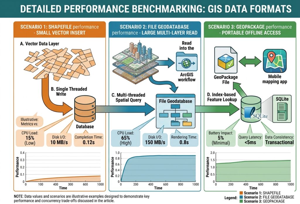
Shapefile performance
Shapefiles can work well for small, simple datasets. Their format is straightforward, and most GIS applications have mature drivers for reading them.
However, attribute and geometry limitations become harder to manage as projects grow. Multiple associated files also create additional administrative work.
File Geodatabase performance
File Geodatabases are designed for structured GIS datasets at substantial scales. They support spatial indexes, efficient geometry storage, and a broad set of geodatabase management tools.
They are particularly effective in ArcGIS-centric projects. Their performance benefits should not be confused with the collaborative editing capabilities of an enterprise geodatabase, however.
GeoPackage performance
GeoPackage benefits from SQLite’s compact storage and transactional database architecture. It is convenient for storing multiple layers, running supported queries, and sharing a complete dataset as one file.
Spatial indexes can improve feature lookups and spatial filtering. However, many simultaneous writers, heavy network usage, or exceptionally large databases may justify moving to a client-server spatial database.
What are spatial indexes?
Spatial indexes reduce the number of geometries that need to be examined during supported spatial queries.
For example, imagine a road dataset containing hundreds of thousands of lines. A GIS operation that identifies roads near a particular point does not ideally need to calculate exact distances to every road. A spatial index can narrow the search to candidate geometries before more detailed testing.
GeoPackage and File Geodatabase support spatial indexing, while Shapefile has more limited index and data-management capabilities. The index implementation, supported query types, and actual speed depend on the software driver.
For large spatial datasets, proper indexing and a well-designed workflow can be just as important as the choice of format.
5. Use Cases: Which Format Fits Your GIS Project?
Scenario A: A university assignment in QGIS
You are preparing a land-cover map with roads, study-area boundaries, sample locations, and a calculated statistics table.
Recommended format: GeoPackage.
It keeps several datasets in one file, uses meaningful column names, supports spatial indexing, and is easy to submit alongside documentation. It is an excellent default for QGIS coursework.
Scenario B: A municipal planning project in ArcGIS Pro
Your team needs domains, subtypes, relationship classes, attachment support, and structured data management for planning assets.
Recommended format: File Geodatabase.
Its geodatabase capabilities are well suited to structured ArcGIS workflows. If several staff members need to edit the same datasets simultaneously with versioning, evaluate an enterprise geodatabase instead.
Scenario C: A client specifically requests a Shapefile
An organization uses a legacy application that accepts only Shapefile data.
Recommended format: Shapefile for delivery, with an internal master in GeoPackage or File Geodatabase.
You can maintain a more capable working dataset and export a Shapefile copy when necessary. Before delivery, check for truncated field names, unsupported values, CRS metadata, and the presence of all required component files.
Scenario D: An offline field-mapping application
You need to distribute administrative boundaries, water bodies, and field observations to a device that will be used without reliable connectivity.
Recommended format: GeoPackage, provided the application supports the required contents.
Its single-file structure makes copying and offline storage convenient. Validate the recipient application’s support for the specific geometry types, attributes, and extensions that you intend to use.
Scenario E: A national dataset with multiple editors
Your project involves frequent updates by several departments, access controls, large spatial tables, and shared database services.
Recommended alternative: PostGIS or an appropriate enterprise geodatabase.
File-oriented storage is convenient for exchanging datasets and supporting individual projects, but a server-based spatial database is better suited to sustained concurrent editing and centralized administration.
6. Migration Guide: Converting Shapefile to GeoPackage or File Geodatabase
If your existing GIS project relies heavily on Shapefiles, you do not need to abandon them all at once. Start by creating a better-managed master copy in a modern format.
Step 1: Audit the source data
Before conversion, check:
- Field names and data types.
- Coordinate reference system.
- Character encoding.
- Geometry validity.
- Feature count and duplicate IDs.
- Associated files and any missing metadata.
This step helps identify problems that a file-format conversion alone will not fix.
Step 2: Choose the target format
For an open-source project or general vector-data exchange, choose GeoPackage.
For an ArcGIS workflow that requires geodatabase rules, domains, subtypes, relationship classes, or attachments, consider File Geodatabase.
Step 3: Convert the dataset
In QGIS, you can use the Export → Save Features As option:
- Right-click the source layer.
- Select Export → Save Features As.
- Choose GeoPackage or a supported output format.
- Specify the output filename and layer name.
- Select the appropriate CRS and encoding options.
- Save the layer.
In ArcGIS Pro, use an appropriate conversion or export tool to move the source features into the target geodatabase or dataset.
Step 4: Validate the output
Compare the source and destination:
- Check the feature count.
- Confirm field names and attribute values.
- Verify the CRS and geometry type.
- Inspect several features on the map.
- Check the output file or geodatabase for successful layer creation.
- Confirm that required indexes, relationships, domains, or attachments were preserved or rebuilt.
A conversion is not complete simply because the output opens successfully. Make sure the data model and attribute meaning are intact.
Step 5: Keep an original copy
Maintain an untouched copy of the original data until you have validated the conversion and any downstream processing. This provides a recovery point if field mappings, geometries, or metadata were altered during export.
7. Final Recommendation: Why Students and Developers Should Default to GeoPackage
For most new GIS coursework, personal projects, environmental studies, and open-source development workflows, GeoPackage is the strongest general-purpose default.
It removes several of the most frustrating Shapefile constraints while retaining broad compatibility across QGIS, GDAL, and many other GIS applications. It also provides convenient multi-layer storage in a portable file, supports spatial indexing, and follows an open OGC specification.
Nevertheless, GeoPackage is not automatically the best choice for every project.
Choose Shapefile when compatibility with a legacy system or an explicit delivery requirement makes it necessary. Choose File Geodatabase when your work depends on advanced Esri geodatabase functionality or an ArcGIS-centric data model. Choose PostGIS or an enterprise geodatabase when centralized administration and concurrent editing are more important than the convenience of a portable file.
The most important professional habit is to select a data format based on your project’s data model, editing needs, scale, interoperability requirements, and delivery constraints—not simply on familiarity.
Further Resources
- OGC GeoPackage Standard — The official open specification and its supported content.
- QGIS Supported Data Formats — How QGIS handles GeoPackage, Shapefile, and other data sources.
- Esri Shapefile Documentation — Shapefile structure and constraints.
- Esri File Geodatabase Documentation — File Geodatabase capabilities and management.
- Esri File Geodatabase Size and Name Limits — Official dataset size and field-name limits.
- GDAL OpenFileGDB Driver — Open-source support for File Geodatabase vector data.
- SQLite: Appropriate Uses — Guidance on SQLite concurrency, data size, and client-server alternatives.