
10 GIS Project Ideas for College Students That Can Build a High-Scoring Portfolio
A strong GIS project is not simply a colorful map. The best GIS project ideas for college students start with a clear geographic problem, use data that can actually be obtained, and apply spatial analysis to produce an answer.
For an undergraduate assignment or capstone, aim for this formula:
Real-world problem + accessible spatial data + appropriate GIS analysis + clear cartographic communication = strong project
You do not need an expensive dataset or advanced software. Many excellent undergraduate GIS projects can be completed using open GIS datasets and free tools such as QGIS.
1. Urban Heat Island Mapping
Category: Urban Planning / Environmental Science
Objective
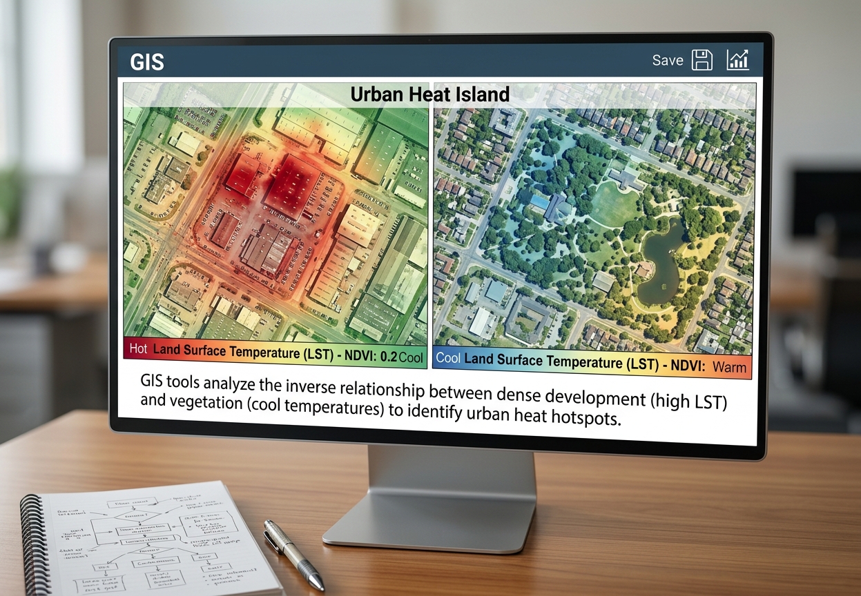
Investigate how land cover and urban development influence surface temperature across a city. The project can identify areas experiencing relatively high land-surface temperatures and examine their relationship with vegetation, buildings, and impervious surfaces.
A possible research question:
Which parts of the study area experience the highest land-surface temperatures, and how are these areas related to vegetation and built-up land?
Suggested Free Data Sources
- USGS EarthExplorer — Landsat imagery
- NASA Earthdata — satellite imagery and environmental datasets
- OpenStreetMap — roads and buildings
- Local government open-data portals
Recommended Tools/Methods
- NDVI calculation
- Land-use/land-cover classification
- Raster Calculator
- Reclassification
- Zonal statistics
- Spatial correlation
- Overlay analysis
Portfolio potential: Portfolio potential: Excellent. This is one of the most complete GIS project ideas for college students to showcase raster analysis and environmental interpretation.
2. Finding the Best Location for a New Public Health Clinic
Category: Health GIS / Urban Planning
Evaluating healthcare accessibility remains one of the most practical GIS project ideas for college students looking to tackle urban planning issues.
Objective
Identify areas that are underserved by existing healthcare facilities and determine suitable locations for a new clinic.
You could consider:
- Population density
- Distance from existing clinics
- Road accessibility
- Residential areas
- Land availability
- Flood-risk areas
Suggested Free Data Sources
- OpenStreetMap — hospitals, roads and settlements
- Census Bureau — U.S. demographic data
- Local census/open-data portals
- Humanitarian OpenStreetMap Team (HOT) datasets
Recommended Tools/Methods
- Buffer analysis
- Euclidean distance
- Spatial join
- Raster reclassification
- Multi-Criteria Evaluation (MCE)
- Weighted overlay
A particularly strong project would explain why each criterion received its assigned weight rather than simply producing a suitability map.
3. Road Accident Hotspot Analysis
Category: Urban Planning / Transport GIS
When studying traffic safety and spatial clustering, this serves as one of the most practical GIS project ideas for college students.
Objective
Identify geographic concentrations of road accidents and investigate their relationship with roads, intersections, land use, or population.
Possible research question:
Where are road accidents concentrated, and what spatial characteristics are associated with these hotspots?
Suggested Free Data Sources
- Government transportation/open-data portals
- OpenStreetMap
- Local police or road-safety datasets where publicly available
- Census population datasets
Recommended Tools/Methods
- Kernel Density Estimation
- Heat maps
- Spatial clustering
- Buffer analysis
- Point pattern analysis
- Network analysis
Possible Output
Produce:
- Accident distribution map
- Hotspot map
- High-risk road/intersection map
- Statistical summary of hotspot characteristics
This is a strong example of GIS being used to move from “where?” to “where should attention be concentrated?”
4. Urban Green Space Accessibility
Category: Urban Planning / Environmental Science
Evaluating urban park coverage is among the top GIS project ideas for college students interested in community planning.
Objective
Assess whether residents have reasonable access to parks and public green spaces.
You could investigate:
Which residential neighborhoods are located outside a 500-metre walking or straight-line distance from a public green space?
Suggested Free Data Sources
- OpenStreetMap
- Municipal GIS portals
- Census Bureau demographic data
- Satellite imagery
Recommended Tools/Methods
- Buffer analysis
- Network analysis
- Service-area analysis
- Population overlay
- Spatial join
For a more sophisticated project, compare straight-line accessibility with actual walking-network accessibility.
That gives you an opportunity to discuss why Euclidean distance does not always represent real-world accessibility, making it one of the most insightful GIS project ideas for college students.
5. Flood Risk and Vulnerability Mapping
Category: Environmental Science / Disaster Management
Flood risk mapping stands out among GIS project ideas for college students because it combines physical environmental factors with population data.
Objective
Identify areas potentially vulnerable to flooding by combining physical environmental factors with human exposure.
Potential variables include:
- Elevation
- Slope
- Drainage
- Distance from rivers
- Rainfall
- Land cover
- Population
Suggested Free Data Sources
- USGS EarthExplorer
- NASA Earthdata
- OpenStreetMap
- Government hydrological datasets
- SRTM/DEM datasets
- Census/open population datasets
Recommended Tools/Methods
- DEM processing
- Slope analysis
- Hydrological analysis
- Flow accumulation
- Watershed delineation
- Distance/buffer analysis
- MCE
- Weighted overlay
Strong Research Question
Which populated areas have the greatest combination of physical flood susceptibility and human exposure?
This turns a simple flood map into a more complete spatial risk assessment.
6. Optimal Location for a Waste Collection Facility
Category: Urban Planning / Logistics
When looking at urban logistics and environmental impact, finding suitable facility locations is one of the most effective GIS project ideas for college students.
Objective
Determine suitable locations for a waste collection or transfer facility while considering accessibility and environmental constraints.
Potential criteria:
- Distance from residential areas
- Road accessibility
- Distance from rivers
- Land-use type
- Slope
- Population density
Suggested Free Data Sources
- OpenStreetMap
- Local land-use datasets
- DEM datasets
- Census data
- Environmental/open-government datasets
Recommended Tools/Methods
- Buffer analysis
- MCE
- Weighted overlay
- Reclassification
- Network analysis
- Proximity analysis
Example Workflow
Data collection → preprocessing → exclusion zones → suitability criteria → weighting → weighted overlay → candidate sites
This makes an excellent spatial analysis portfolio project because it demonstrates decision-support GIS rather than simply map production.
7. School Accessibility and Service Coverage
Category: Education / Urban Planning
Analyzing educational service coverage provides one of the best GIS project ideas for college students working with network datasets.
Objective
Analyze how accessible schools are to the surrounding population and identify potentially underserved areas.
You could investigate:
Which residential areas are located more than a specified travel distance from an existing school?
Suggested Free Data Sources
- OpenStreetMap
- Census population datasets
- Government education datasets
- Administrative boundaries
Recommended Tools/Methods
- Network analysis
- Service-area analysis
- Buffer analysis
- Population-weighted accessibility
- Spatial joins
Advanced Version
Instead of simply counting schools, calculate: Population within service area ÷ total population. This elevates simple accessibility maps into high-scoring GIS project ideas for college students.
This produces a more meaningful accessibility measure.
8. Optimal Route for Emergency Services
Category: Logistics / Public Safety
Analyzing network response times is one of the top GIS project ideas for college students interested in public safety and logistics.
Objective
Analyze road-network accessibility for emergency vehicles and identify areas where response times may be constrained.
Potential applications include:
- Ambulances
- Fire services
- Police
- Disaster response
Suggested Free Data Sources
- OpenStreetMap road network
- Open government datasets
- Administrative boundaries
- Population datasets
Recommended Tools/Methods
- Network analysis
- Shortest-path analysis
- Service-area analysis
- Travel-time modeling
- Origin-destination analysis
Possible Research Question
Which neighborhoods can be reached within 10, 15, and 20 minutes from an emergency facility under the selected network assumptions?
Be explicit about assumptions such as travel speed, road restrictions, and network completeness.
9. Vegetation Change Detection
Category: Environmental Science / Remote Sensing Objective
Measure changes in vegetation across a selected study area over time.
For example, compare satellite imagery from two or more years to investigate:
- Deforestation
- Urban expansion
- Agricultural change
- Vegetation recovery
- Drought effects
Suggested Free Data Sources
- USGS EarthExplorer
- NASA Earthdata
- Sentinel data through Copernicus Data Space
- OpenStreetMap for supporting geographic features
Recommended Tools/Methods
- NDVI
- Raster Calculator
- Image classification
- Change detection
- Raster differencing
- Zonal statistics
Example
Calculate:
NDVI=NIR−RedNIR+RedNDVI = \frac{NIR-Red}{NIR+Red}
Then compare NDVI values from different dates.
The important part is not merely creating two NDVI maps. Explain where vegetation changed, how much it changed, and what geographic factors might explain the pattern.If you want to focus on environmental remote sensing, monitoring land-cover shifts over time offers one of the best GIS project ideas for college students.
10. Optimizing Delivery Routes
Category: Logistics / Business GIS
Route optimization provides a clear business use case, making it one of the best GIS project ideas for college students entering commercial GIS.
Objective
Develop an efficient delivery route connecting multiple customers, warehouses, or distribution points.
This could simulate:
- Food delivery
- Parcel delivery
- Agricultural products
- Medical supplies
- Retail distribution
Suggested Free Data Sources
- OpenStreetMap
- Open government road datasets
- Business/customer locations generated for the project
- Administrative boundaries
Recommended Tools/Methods
- Network analysis
- Shortest-path analysis
- Route optimization
- Origin-destination matrices
- Travel-time analysis
- Location-allocation
Portfolio Extension
Create two scenarios:
Scenario A: Existing delivery strategy
Scenario B: GIS-optimized strategy
Then compare:
- Distance
- Estimated travel time
- Number of routes
- Service coverage
This gives your project a clear analytical question and measurable outcome.
How to Choose the Right Project
Don’t choose a project simply because the title sounds impressive.
Match the project to the GIS skills you want to demonstrate.
| If you want to demonstrate… | Consider… |
|---|---|
| Raster analysis | Urban heat island |
| Remote sensing | Vegetation change |
| Environmental GIS | Flood risk |
| Urban planning | Green-space accessibility |
| Health GIS | Clinic accessibility |
| Network analysis | Emergency routing |
| Logistics | Delivery optimization |
| MCE | Waste facility/site suitability |
| Spatial statistics | Accident hotspots |
| Cartography | Any of the above |
Comparing these subfields helps you select the right GIS project ideas for college students based on the spatial tools you want to highlight.
For a spatial analysis portfolio, combining several methods is particularly useful. For example:
DEM + land cover + roads + population + MCE → Flood-risk suitability model
That demonstrates much more than producing a single thematic map.
Pro-Tips for Getting an A+
1. Start with the research question
When executing any of these GIS project ideas for college students, following a structured methodology ensures your final portfolio project scores top marks.
Don’t begin with:
“What GIS tools can I use?”
Begin with:
“What geographic problem am I trying to answer?”
Then select the tools that answer that question.
2. Don’t use every GIS tool you know
More analysis does not automatically mean a better project.
A focused project using three appropriate methods is usually more defensible than a project containing ten unrelated tools.
3. Make your methodology reproducible
Record:
- Dataset names
- Sources
- Download dates
- CRS
- Spatial resolution
- Processing tools
- Parameters
- Selection criteria
- Classification methods
Someone should be able to understand your workflow without watching you perform it.
4. Treat cartography as part of the analysis
A technically correct analysis can still look weak if the final map is poorly designed.
Check:
- Clear title
- Appropriate legend
- Scale bar
- North arrow where useful
- Readable labels
- Appropriate symbology
- Good visual hierarchy
- Correct map extent
- Data sources
- Author/date information
Avoid filling the map with decorative elements that don’t improve geographic communication.
5. Cite spatial data properly
Open data is still data that needs attribution.
For every major dataset, record:
Dataset name → Organization → Year/version → URL/catalog → Access date → License/attribution requirements
For example:
OpenStreetMap contributors. OpenStreetMap data, accessed [date], [license/attribution information].
Follow the specific attribution requirements of the dataset provider.
6. Keep your original data separate from processed data
A simple project structure can prevent a lot of confusion:
GIS_PROJECT/
│
├── data_raw/
├── data_processed/
├── qgis_project/
├── outputs/
├── maps/
├── figures/
└── report/
Never overwrite your original downloaded datasets unnecessarily.
The A+ Project Formula
When choosing between potential GIS project ideas for college students, ask five questions: By picking one of these GIS project ideas for college students, you can build an impressive portfolio that demonstrates real spatial analysis skills.
1. Is there a clear geographic problem?
2. Can I obtain reliable data?
3. Does the problem require spatial analysis?
4. Can I produce measurable results?
5. Can I communicate those results through a professional map and report?
If you can answer yes to all five, you have the foundation of a strong undergraduate GIS project.
And remember: the sophistication of a GIS project is not determined by how many tools you use. It is determined by how clearly your spatial analysis answers the problem you set out to investigate.