
ArcGIS Pro vs QGIS for Coursework:A The Ultimate Student Survival Guide
It is Sunday night, your spatial analysis assignment is due at midnight, and your screen is either locked on a spinning wheel or throwing a fatal coordinate system error. Every geography, environmental science, and urban planning student hits this exact crossroads. When evaluating ArcGIS Pro vs QGIS for coursework, choosing the wrong software for your specific hardware or project requirements can turn a simple mapping lab into hours of unnecessary frustration.
Esri’s ArGIS Pro is the dominant commercial standard across corporate and government sectors. QGIS is the open-source champion—a lightweight, free power-player backed by a massive global community. Both platforms handle vector editing, raster calculation, and complex spatial queries with ease. However, when you are balancing tight university deadlines, limited budgets, and varying laptop specs, one software will clearly fit your academic needs better than the other.
ArcGIS Pro vs QGIS: Head-to-Head Comparison Factors
Licensing & Budget
When weighing ArcGIS Pro vs QGIS for a student budget, licensing models play a major role in your decision.Understanding the cost structure of ArcGIS Pro vs QGIS helps students choose the right software before their term begins.
- QGIS: Free forever under the GNU General Public License. You can download it on your personal laptop, install it on unlimited devices, and retain full access to your project files long after graduation without spending a dime.
- ArcGIS Pro: Commercial proprietary software. While most universities provide students with an institutional named-user license (via organizational ArcGIS Online accounts), these licenses typically expire the moment you complete your module or graduate. If your university does not provide a license key, an individual student license costs roughly $100 per year.
Operating System & Performance
Operating system compatibility is another critical factor in the ArcGIS Pro vs QGIS debate, especially if you rely on a Mac.
- Mac vs. Windows: QGIS runs natively on macOS, Windows, and Linux. If you use a MacBook—especially an Apple Silicon chip (M1/M2/M3/M4)—QGIS installs directly and runs smoothly. ArcGIS Pro is strictly Windows-only. Running ArcGIS Pro on a Mac requires setting up a virtual machine (like Parallels) or using Boot Camp on older Intel Macbooks, which heavy spatial processing can crash.
- System Resource Demands: ArcGIS Pro utilizes a 64-bit multi-threaded architecture that demands significant hardware power (minimum 16 GB RAM and a dedicated GPU recommended). QGIS is remarkably lightweight, launching quickly and running smoothly even on older laptops with basic integrated graphics.
Learning Curve & User Interface
When evaluating the overall usability of ArcGIS Pro vs QGIS, the user interface design plays a massive role in student workflow speed. Comparing the user interface of ArcGIS Pro vs QGIS shows two distinctly different approaches to software navigation.
- ArcGIS Pro (Contextual Ribbon UI): Mirrors Microsoft Office with a modern ribbon bar across the top. Tabs dynamically shift based on what you select (e.g., clicking a raster layer opens the Raster Layer and Appearance tabs). This layout makes tools easier to visually discover for beginners, though nested menus can sometimes obscure advanced geoprocessing options.
- QGIS (Traditional Dock Interface): Uses classic toolbars, drop-down menus, and customizable side panels. While it may look slightly less modern out of the box, it offers complete control over your workspace. You can drag, dock, or hide any panel to maximize your canvas area.
Cartography & Layout Design for Assignments
In terms of map design and export capabilities, the ArcGIS Pro vs QGIS battle comes down to automated templates versus fine-grained design control.
- ArcGIS Pro: Features intuitive cartographic tools, sophisticated 3D scene integration, and pre-built map templates. Adding dynamic legend items, scale bars, and north arrows to map layouts is seamless, making it easy to create presentation-ready deliverables for class reports.
- QGIS (Print Layout Engine): Offers exceptional design flexibility through its built-in Print Layout tool. It provides fine-grained control over DPI exports, vector rendering, map atlas generation (automating multi-page map series), and spatial masking. However, adjusting legend formatting and layout elements manually requires a bit more hands-on setup compared to Pro.
Quick Decision Framework: When to Use Which
leDecision framework comparing ArcGIS Pro and QGIS features, pricing, OS support, and tools for students.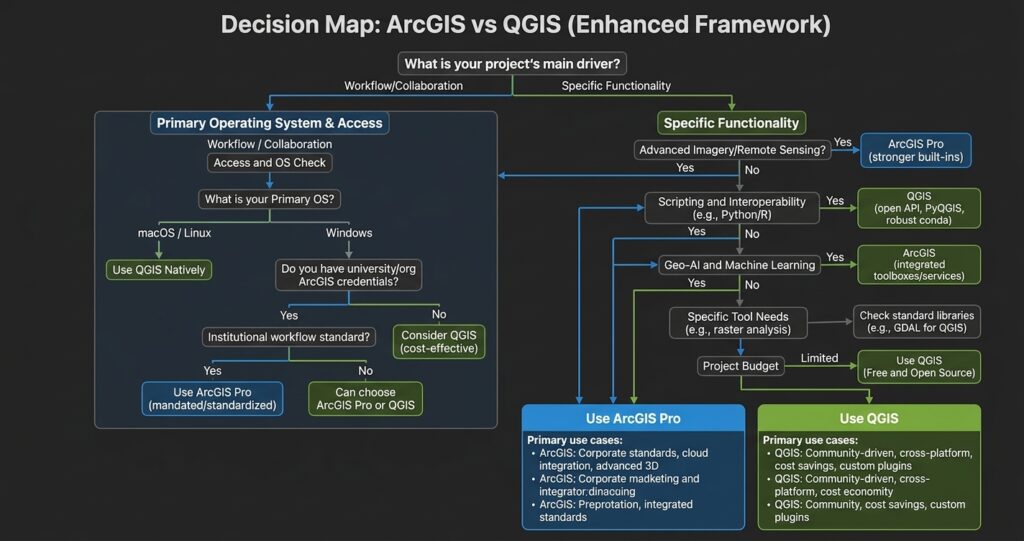
Use ArcGIS Pro if:
- You run a high-spec Windows laptop with a dedicated graphics card.
- Your professor explicitly grades assignments using Esri-specific formats like File Geodatabases (.gdb), ArcGIS Online StoryMaps, or ArcPy scripts.
- Your coursework heavily emphasizes advanced 3D spatial modeling, network dataset routing, or deep learning toolsets.
- You want to master the software platform most widely cited in enterprise job descriptions.
Use QGIS if:
- You use a Mac or Linux computer and want native, stable performance without running virtual machines.
- You are working on a budget and do not have institutional access to Esri software licenses.
- Your laptop has lower-tier hardware specs that struggle under resource-heavy applications.
- You need niche spatial analysis tools provided by third-party plugins (such as GRASS GIS or Saga GIS integrations).
Common Software Errors & Quick Fixes
1. The “Unknown Coordinate System” or Alignment Error
- The Problem: You load two layers (e.g., city boundaries and road networks), but your map canvas is blank or the layers land thousands of miles apart.
- The Fix in ArcGIS Pro: Right-click the missing layer in the Contents pane $\rightarrow$ select Properties $\rightarrow$ go to Spatial Reference. If it reads Unknown, search for the correct coordinate system using the Define Projection geoprocessing tool (do not use Project until the initial system is set).
- The Fix in QGIS: Look for the red question mark icon next to the layer in the Layers panel. Click it to open layer properties, set the correct Assigned CRS, or right-click the layer $\rightarrow$ Set CRS $\rightarrow$ Set Layer CRS.
2. The Dreaded Lock File / Uneditable Layer
- The Problem: You try to edit an attribute table or delete a field, but the software tells you the dataset is read-only or locked by another process.
- The Fix in ArcGIS Pro: Close any active attribute tables or external programs (like Microsoft Excel) that might be reading the same File Geodatabase. If the issue persists, save your project, restart ArcGIS Pro, and delete any leftover .lock files inside your .gdb folder.
- The Fix in QGIS: Save your layer edits by toggling off the yellow Toggle Editing pencil icon before attempting structural edits. If the format (like a raw CSV) does not support editing, right-click the layer $\rightarrow$ Export $\rightarrow$ Save Features As… and save it as a native GeoPackage (.gpkg).
3. Missing Toolbars or Geoprocessing Panes
- The Problem: You accidentally close your main panel and can no longer locate the tool search bar or layer list.
- The Fix in ArcGIS Pro: Click the View tab on the top ribbon $\rightarrow$ click Reset Panes $\rightarrow$ select Reset Panes to Default.
- The Fix in QGIS: Right-click any empty space on the top toolbar menu $\rightarrow$ check the boxes for Panels (ensure Layers and Processing Toolbox are checked).
Mastering Your GIS Assignments
Whether you choose ArcGIS Pro or QGIS, both software packages equip you with the essential spatial analysis capabilities required for academic success. ArcGIS Pro provides a polished entry point into enterprise workflows, whereas QGIS delivers open-source flexibility across all operating systems. Focus on mastering core spatial concepts—such as coordinate reference systems, raster vs. vector operations, and clear cartographic layout principles—and the software skills will naturally follow.”Ultimately, both platforms have their strengths, and testing ArcGIS Pro vs QGIS on your own projects is the best way to determine your preferred workflow
If you are stuck on a complex spatial query, struggling to debug Python scripts, or need assistance crafting map layouts for your term project, Help With My GIS Assignment is here to support you. Reach out to our team today for personalized, 1-on-1 spatial analysis mentoring and step-by-step project guidance tailored directly to your curriculum!